What is recorded here
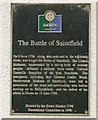
Black plaque on Saintfield High School records that on 9 June 1798 United Irishmen country people defeated Colonel Granville Stapylton’s York Fencibles along Belfast Road and in adjoining fields. Rev Thomas Leslie Birch, Presbyterian Minister of Saintfield, fought beside them, and the insurgents held the town before moving toward Ballynahinch and the later defeat in Down on 13 June 1798.
This black commemorative plaque records: The Battle of Saintfield. On 9 June 1798, along this road and in the adjoining fields, was fought the Battle of Saintfield. The United Irishmen, represented by a strong body of country people, defeated a military force under Colonel Granville Stapylton of the York Fencibles. The insurgents, including Rev Thomas Leslie Birch, Presbyterian Minister of Saintfield, were left in possession of the town and surrounding area before moving on to Ballynahinch, and the defeat of the rebels in Down on 13 June 1798 Recorded plaque organisation: Down District 1798 Bicentenary Committee.
The United Irishmen were a republican revolutionary group active in Ireland during the late 18th century, significant for their role in organizing rebellions against British rule; Major General Granville Anson Chetwynd-Stapylton and Rev Thomas Leslie Birch were key figures at the Battle of Saintfield, where Birch led insurgents alongside United Irishmen forces against government troops under Stapylton's command.
A plaque record does not grant entry to a building or private land. View it from a public place unless permission is clearly given.
Places near here
 Battle of Saintfield (1798)Battlefield · 28 yd
.jpg?width=1280) Saintfield StationRailway Station Structures · 558 yd
Saintfield StationRailway Station Structures · 558 yd First Presbyterian ChurchChurch · 641 yd
 ENCLOSURE & WINDMILL (stump): WINDMILL HILLENCLOSURE & WINDMILL (stump): WINDMILL HILL, IHR 02919 · 809 yd
 ENCLOSURE in BallyaghertyENCLOSURE · 853 yd
 Glasswater WoodWood · 4.4 mi
 Battle of Ballynahinchbattle · 4.6 mi
 Windmill HillMountain / peak · 5.0 mi
 Windmill Hill WoodWood · 5.1 mi
 Lisburn Street North Car ParkVisitor information · 5.1 mi
 Windmill Street Car ParkVisitor information · 5.1 mi
 Post-Medieval church & graveyard in TullynakillPost-Medieval church & graveyard · 6.5 mi
Other information
Photo: Albert Bridge on Geograph · CC BY-SA 2.0