
What is recorded here
On S side of Awbeg River, to SE of Water House and Clapper Bridge (14940, 14839). Two-storey early-19th century entrance front, with bow ends and hipped roof: central door with side lights and fanlight incorporated into frame. This built against double-gable ended 18th century house, on same axis (Bence-Jones 1978, 263). Earlier section has chimney stacks atop gables and narrow sash windows, but its rear elevation (NNW) is concealed behind additions. Ranges of 2-storey farm buildings to E and N. Shallow rectangular stone-lined pond (c. 30m NW-SE; 4.35m SW-NE) to NW, known locally as 'Monk's pond'; overflow outlet at NW end covered by large stone slab. Possibly associated with Clapper bridge (14839) in line to NW.
The above description is derived from the published 'Archaeological Inventory of County Cork. Volume 4: North Cork' (Dublin: Stationery Office, 2000). In certain instances the entries have been revised and updated in the light of recent research.
Date of upload/revision: 14 January 2009
The monument record does not grant public access. Check the route and ask the landowner before entering private land.
- What survives
- Recorded monument
Places near here
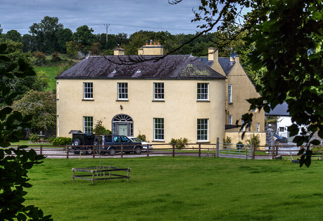 Springfieldcountry house · 9 yd
 Fish-pond in Ballybeg EastFish-pond · 62 yd
 Clapper Bridgefoot bridge · 114 yd
 Earthwork in Ballybeg EastEarthwork · 617 yd
 Charles BunworthMemorial · 901 yd
 Lombards CastleCastle, tower house · 1168 yd
 SycamoreSycamore · 1592 yd
 David HurleyMemorial · 1594 yd
 CastleCastle, unclassified · 1.5 mi
 Smith's WellSpring · 3.0 mi
 Doneraile HouseHeritage attraction · 3.3 mi
 European YewEuropean Yew · 3.5 mi
Other information
Photo: Mike Searle · CC BY-SA 2.0