What is recorded here
Situated in a low-lying landscape. It is depicted as a rectangular structure on the 1834 edition of the OS 6-inch map where it is described in italic lettering as ‘R. C. Church.’ This is a post-penal Roman Catholic church which was renovated in 1891 but which is now closed. It is in a subtriangular graveyard (dims c. 45-75m E-W; c. 40m N-S) extending E from a NW-SE road, and is defined by masonry walls. It has rather few headstones dating largely from the nineteenth century. There is no evidence that there was a mass-rock here (Ó Gallachair 1957, 119).
Date of revised upload: 12 December 2017
The monument record does not grant public access. Check the route and ask the landowner before entering private land.
- What survives
- Recorded monument
Places near here
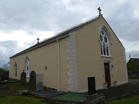 Saint Anne's Catholic Churchchurch/chapel · 1 yd
 Grave Yd.Graveyard · 19 yd
 water pumpwater pump · 125 yd
 IndicatedMound · 908 yd
 Mannan Castle (in ruins)Castle, Anglo-Norman masonry castle · 2.7 mi
 TobernagalliaghSpring · 3.9 mi
 KnockreaghMountain / peak · 3.9 mi
 Horse-chestnutHorse-chestnut · 4.7 mi
 CastleCastle, unclassified · 5.0 mi
 European BeechEuropean Beech · 5.3 mi
 MEDIEVAL & POST-MED. CHURCH & GRAVEYARD in Creggan Bane GlebeMEDIEVAL & POST-MED. CHURCH & GRAVEYARD · 5.5 mi
 Fincarn HillMountain / peak · 6.0 mi