What is recorded here
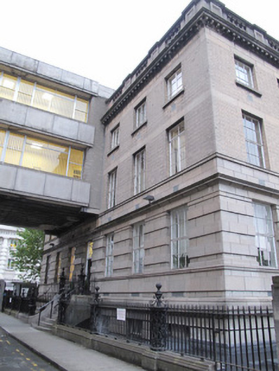
Attached L-plan seven-bay three-storey over basement office building, built 1911-13, having fifteen-bay north elevation, and recent building adjoining front (west) elevation at first floor. Flat roof hidden behind ashlar granite balustrade parapet over carved cornice. Grey brick laid in Flemish bond to first and second floors, platbands of Portland stone over windows. Continuous cut granite sill course to first floor, over channelled render to ground floor, with carved granite cornice over windows, continuous granite sill course, and carved granite plinth course over channelled rendered wall to basement. Square-headed window openings throughout: some having steel-framed windows, some with replacement uPVC windows. Grilles to windows at basement level. Square-headed door opening to front having double-leaf timber panelled door and overlight. Door opening onto platform bridging basement area, cut granite steps to footpath, enclosed by wrought-iron railings with cast-iron newel posts, set on carved granite plinth walls. Railing surrounding front and north side of building.
Designed by J. Howard Pentland and built by J&R Thompson of Fairview, the Land Registry building forms part of the complex of civic buildings on Inns Quay, contextualised by the presence of the Four Courts to the south and the Public Records Office to the west. It was built at an estimated cost of £14,470. It employs classical vocabulary and is enlivened by carved granite detailing, which draws a comparison between it and its neighbouring buildings. However, it combines these elements with more recent construction technology, incorporating an early concrete frame and concrete brick walling, providing technical architectural interest. Notwithstanding the addition of an office block to the upper façade in the 1960s, the architectural significance of this building is evident.
This does not grant access. Most recorded buildings are privately owned; view them only from public ground unless the owner allows entry.
Places near here
 Bridewell Garda Stationprison/jail · 47 yd
 Metropolitan District Court Housecourt house · 50 yd
 Burnt mound in Unknown TownlandBurnt mound · 112 yd
 Courthouse in Unknown TownlandCourthouse · 127 yd
 Old Jameson DistilleryMuseum · 278 yd
 Saint Audoen's GateHeritage attraction · 341 yd
 Gairdín Súgartha i gCuimhne ar na Páistí a Cailleadh in 1916Memorial · 363 yd
 Medieval DublinVisitor information · 448 yd
 London PlaneLondon Plane · 651 yd
 Apple OrchardVisitor information · 801 yd
 European PearEuropean Pear · 802 yd
 Croppies Acre MemorialMemorial · 870 yd
Other information
Photo: National Inventory of Architectural Heritage · Website use allowed for educational or private purposes with source credit