What is recorded here
In a demesne, overlooking Lough Arrow to the S. The present early 19th-century Ballindoon House (Bence-Jones 1988, 18) is reputed to be on the site of a 17th-century house (SL034-213----) (pers. comm. M. A. Timoney). That house may have been the small rectangular structure (roughly on the site of the present house) indicated on the 1838 OS 6-inch map at the SE end of a tree-lined linear avenue (L c. 400m). This avenue (Wth 16m) is cambered and flanked on either side by a drain (Wth 2.5m; int. D 0.2m; ext. D 0.5m to the top of the external bank) with a low broad external earthen bank (Wth 2m; ext. H 0.6m). The central portion has a gravel surface but otherwise it is entirely an earthen construction. It is similar to the avenue at Annaghmore (SL026-049----) and is probably 17th/early 18th-century in date. Another house, named 'Kingsborough Ho.', which no longer survives, is indicated on the 1838 OS 6-inch map, c. 50m to the S of the present Ballindoon House. According to local information, stones from the nearby Ballindoon Castle (SL034-220001-), c. 0.9km to the SE, were taken to build Ballindoon House.
Compiled by: Archaeological Survey Unit, UCC with revisions by Patrick F. O'Donovan and Paul Walsh
Date of upload: 20 June 2011
The monument record does not grant public access. Check the route and ask the landowner before entering private land.
- What survives
- Recorded monument
Places near here
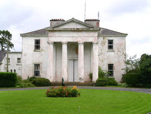 Ballindoon Housecountry house · 270 yd
 Enclosure in BallindoonEnclosure · 534 yd
 St Dominicks StoneFont · 780 yd
 Ballindoon AbbeyRuins · 786 yd
 Annaghgowla IslandIslet · 1203 yd
 Ballindoon Castle (in Ruins)Castle, unclassified · 1244 yd
 TumulusCastle, motte · 1473 yd
 InishmoreIslet · 1559 yd
 Barroe NorthMountain / peak · 1.4 mi
 Loughbrick BayBay · 2.0 mi
 Bricklieve MountainsMountain / peak · 2.7 mi
 Treanscrabbagh caveCave · 3.1 mi