What is recorded here
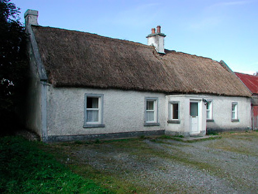
Detached five-bay single-storey vernacular house, built c.1820, with a single-bay flat-roofed porch to the centre of the front elevation (southeast) and flat roof extension to rear (northwest). Pitched long straw thatched roof with rendered chimneystacks to the centre and west gable end. Rendered verges to gables. Roughcast rendered walls over smooth rendered plinth with rendered bands to margins/corners. Ruled-and-line rendered finish to porch. Square-headed window openings with rendered reveals, painted cut stone sills and replacement uPVC windows. Square-headed door to front face of porch having replacement door. Set back from road, at a right angle to road alignment, to the south of Loughanavally with rendered boundary wall to the southwest. Early cast-iron hand pump to site. Rendered single-storey outbuildings to east and south.
A typical example of an early-to-mid nineteenth-century vernacular house/farmhouse, which retains its early character despite the loss of some of its fabric in recent years. The position of the chimneystacks indicates that this structure was extended to the northeast along the line of the existing building, which is a common feature of Irish vernacular houses of this type. This building is set at a right angle to the road alignment, another typical feature of this type of structure. This building is thatched using traditional long straw thatch, a building material that is rapidly disappearing from the Irish countryside. This building is an interesting feature in the rural landscape to the south of Loughanavally, adding a picturesque element to this rural location, and is an integral element of the vernacular heritage of Westmeath.
This does not grant access. Most recorded buildings are privately owned; view them only from public ground unless the owner allows entry.
Places near here
 Taghboyne Church in ruinsChurch · 389 yd
 Redmondstowndemesne walls/gates/railings · 530 yd
 Dotted outlineFairy fort / earthen ringfort · 844 yd
 OutlinedFairy fort / earthen ringfort · 877 yd
 CastleCastle, unclassified · 1093 yd
 Carn CastleCastle · 1550 yd
 Hill of UisneachMountain / peak · 1.8 mi
 Ancient Ring FortWood · 2.2 mi
 European ashEuropean ash · 2.4 mi
 KnockastiaMountain / peak · 4.9 mi
 Abbeyshrule AbbeyRuins · 9.0 mi
 Guest ServicesVisitor information · 9.4 mi
Other information
Photo: National Inventory of Architectural Heritage · Website use allowed for educational or private purposes with source credit