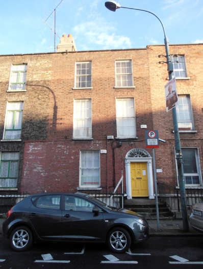
What is recorded here
Terraced three-bay three-storey house over raised basement, built c.1810, now in use as office. One of group of three. Hipped slate roof behind parapet with granite coping, corbelled rendered chimneystack with terracotta pots. No visible rainwater goods. Red brick walling laid down in Flemish bond, painted to first floor level. Granite plinth course over rendered wall to basement area. Gauged flat-arched window openings, with patent rendered reveals, painted sills, and replacement six-over-six pane timber sliding sash windows. Segmental-headed door opening with stone surround having timber panelled door, flanked by engaged Ionic columns supporting fluted frieze and stepped cornice with decorative leaded fanlight. Door opens onto granite platform with three granite steps, bridging basement, flanked by wrought-iron handrails. Area bounded by granite plinths surmounted by wrought-iron railings with spike finials.
Amiens Street was originally known as 'The Strand', with its name changed c.1800 in honour of Viscount Amiens, later the Earl of Aldborough. This group of houses was built in the style characteristic of the early Georgian period with pleasing proportions and fine detailing. The character of the surrounding area was greatly impacted by the arrival of the railway era within a couple of decades of the construction of the houses. The survival of the Adamesque doorcase contributes greatly to its architectural heritage significance.
This does not grant access. Most recorded buildings are privately owned; view them only from public ground unless the owner allows entry.
Places near here
 Health Service Executivehouse · 14 yd
 Preston Househouse · 23 yd
 HomeMonument · 196 yd
 Captain Séan ConnollyMemorial · 199 yd
 Irish Rail InformationVisitor information · 254 yd
 1974 Dublin and Monaghan Bombings MemorialMonument · 263 yd
 EPIC The Irish Emigration MuseumMuseum · 580 yd
 17 October UN International Day for the Eradication of PovertyMonument · 620 yd
 Burning of the Custom Housearmed conflict · 657 yd
 Custom House Visitor CentreHeritage attraction · 665 yd
 1GQVisitor information · 766 yd
 Burial ground in Unknown TownlandBurial ground · 926 yd
Other information
Photo: National Inventory of Architectural Heritage · Website use allowed for educational or private purposes with source credit