What is recorded here
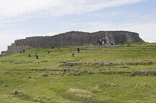
During the course of research excavations in the SE area (Cutting 3) of the middle enclosure of Dún Aonghasa (GA110-039----) a largely man-made hollow (L 6m; Wth 5-7m), identified as F325, was uncovered. It was created by quarrying back into the terraced slope at the SE end of the enclosure. Vertical rock faces defined its S and W sides. The return of the SE side formed a footing for the enclosure wall for a distance of 0.9m at which point it turned E and disappeared in under the wall. The enclosure wall would have afforded the hollow protection from the easterly winds and it is likely that there was formerly a wall along the cliff edge to protect it from the south-westerly winds; however, no trace of the latter wall survives. Occupational deposits on the floor of the hollow, consisting of dispersed animal bone and charcoal flecks, continued in under the wall-face, indicating that it was hollowed out prior to the construction of the later phase of the enclosing wall (Cotter 2012, vol. 1, 228-230).
Compiled by: Olive Alcock
Date of upload: 23 June 2020
The monument record does not grant public access. Check the route and ask the landowner before entering private land.
- What survives
- Recorded monument
Places near here
 Dún AonghasaNature reserve · 72 yd
 Not locatedStructure · 85 yd
 DunaengusCliff-edge fort · 100 yd
 Kilmurvey BeachBeach / strand · 309 yd
 TemplenaneeveChurch · 890 yd
 IndicatedChurch · 1314 yd
 ÁrainnIsland · 1.5 mi
 Castle (in ruins)Castle, unclassified · 1.6 mi
 An CharcairMountain / peak · 1.9 mi
 Seal Colony LookoutViewpoint · 2.3 mi
 An tOileán ThiarIslet · 3.6 mi
 Trá na mBuailte (Beach of the Booly)Beach / strand · 4.0 mi
Other information
Photo: Credit not shown in the picture search · Rights wording not checked; contact us if this picture should be removed