What is recorded here
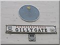
This blue commemorative plaque records: Gillygate First recorded about 1240. The street leading to St. Giles Church and formerly the main approach to the town from the south. Recorded plaque organisation: Rotary International.
Gillygate, first recorded around 1240, served as the primary southern access route into Pontefract and led to St. Giles Church, reflecting its historical importance in the town's urban layout and religious life.
A plaque record does not grant entry to a building or private land. View it from a public place unless permission is clearly given.
Places near here
_-_Coat_of_Arms,_41_Market_Place,_Pontefract_(geograph_5555224).jpg?width=1280) 3, Market PlaceListed building · 18 yd
3, Market PlaceListed building · 18 yd Town HallListed building · 35 yd
 Roman Milestone in Pontefract museumMonument or public art · 207 yd
 War MemorialMemorial · 242 yd
 Recently Erected Sculpture, Micklegate Square, PontefractPublic sculpture · 348 yd
.jpg?width=1280) Pontefract Castle Visitors CentreVisitor information · 590 yd
Pontefract Castle Visitors CentreVisitor information · 590 yd Pontefract CastleCastle · 600 yd
 Hunters StadiumStadium · 669 yd
 The RookeriesWood · 1.0 mi
 Who stole the milestone marker?Monument or public art · 1.3 mi
 Holywell WoodWood · 1.7 mi
 Battle of FerrybridgeMajor battlefield · 2.1 mi
Other information
Photo: Mike Kirby on Geograph · CC BY-SA 2.0