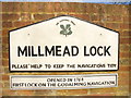
What is recorded here
This commemorative plaque records: The Wey & Godalming Navigations Sir Richard Weston wished to make the River Wey navigable between Guildford and the Thames. He had already experimented with locks and irrigation channels on his estate at Sutton Place, north of Guildford. In 1651, an Act of Parliament empowered a group of men led by Weston to carry out the work. Although it proceeded rapidly, the project went over the budget and there were many disputes about the finances. Despite these troubles the Navigation was finished by 1653 and was an immediate success. The Wey Navigation reached as far as the Town Wharf, just downstream of the bridge. In 1760 another Act of Parliament was obtained for a navigation upstream to Godalming. The Godalming extension involved enlarging the centre arch of Guildford's Town Bridge and dredging out the ford alongside it to allow the barges to pass. Millmead Lock was built here in 1762 to raise barges to the millstream, embanked above the natural level of the river. The principal cargoes carried were timber, coal and corn. Many other goods were carried, notably gunpwder from the mills at Chilworth and chalk from the nearby quarries for lime. The arrival of the railway in 1845 began the decline of the Wey and Godalming Navigations, but they continued to carry commercial cargoes until 1969. The navigations were presented to the National Trust by their last owner, Harry Stevens, and while no longer carrying cargo are much used by pleasure craft. Recorded plaque organisation: Guildford Historic Trail.
Sir Richard Weston was a prominent English landowner who initiated the Wey & Godalming Navigations in the mid-17th century, significantly enhancing trade and transportation between Guildford and the Thames through innovative engineering solutions. The navigations, despite facing financial and logistical challenges, became crucial for transporting goods like timber, coal, corn, gunpowder, and chalk until their decline with the advent of railways in the 19th century.
A plaque record does not grant entry to a building or private land. View it from a public place unless permission is clearly given.
Places near here
 Yvonne Arnaud TheatreListed building · 61 yd
 Town MillListed building · 112 yd
 Guildford MuseumMuseum · 151 yd
 Alice's Statue, Guildford RiversideMonument or public art · 212 yd
 Guildford CastleScheduled monument · 218 yd
 CastleViewpoint · 236 yd
 War MemorialMemorial · 298 yd
 Guildford pub bombingsbomb attack · 555 yd
 Guildford Borough Boundary StoneMonument or public art · 648 yd
 Pewley HillMountain / peak · 950 yd
 Grotto Below St Catherine's HillCave or cavern · 975 yd
 St Catherine's HillMountain / peak · 1087 yd
Other information
Photo: Colin Smith on Geograph · CC BY-SA 2.0