
What is recorded here
Downhill church and graveyard stand scheduled in County Derry, preserving a medieval to seventeenth-century place where worship and death shared one ground. The site has watched generations bury their dead beside a building old enough to predate written memory in some of its layers. People may have prayed at dawn, walked home through rain, and returned only when loss called them back.
The official Northern Ireland record identifies this as CHURCH & GRAVEYARD. Recorded period: C17TH; MED/L.MED; E.C./MED. Recorded protection: Scheduled. The official map point was placed at the centre of the recorded archaeological site from the source map reference.
The monument record does not grant public access. Check the route and ask the landowner before entering private land.
- What survives
- Recorded monument
Places near here
 MausoleumMonument · 210 yd
 Earl Bishop's Tree Trail, DownhillWalking route · 321 yd
 PROMONTORY FORT: DUNGANNON FORT in DownhillPROMONTORY FORT: DUNGANNON FORT · 431 yd
 Downhill DemesneVisitor information · 467 yd
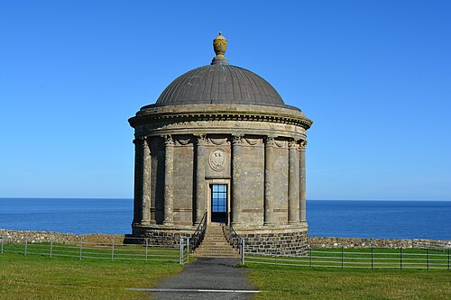 Mussenden TempleHeritage attraction · 936 yd
 St. Mary's RC ChurchChurch · 1008 yd
 Downhill BeachVisitor information · 1023 yd
 Christ ChurchChurch · 1517 yd
 Castlerock BeachBeach / strand · 1.3 mi
 Ballyhacket ViewPicnic place · 2.2 mi
 Portstewart StrandBeach / strand · 2.6 mi
 CASTLE & SETTLEMENT SITE (unlocated) in GlebeCASTLE & SETTLEMENT SITE (unlocated) · 3.8 mi
Other information
Photo: Kenneth Allen · CC BY-SA 2.0