
What is recorded here
St. Kieran the elder founded the Burying Ground in the fifth century, shaping a square graveyard where a round tower base still marks the northwest and a high cross stands in the centre. Later churches, a gun turret, cross-slabs and the earthworks of a deserted medieval settlement layered the place, while a bivallate enclosure still surrounds the whole. It is not a polished monument but a lived landscape, with burial, worship and defence tangled together beneath the grass.
Large square-shaped graveyard with poorly preserved church (OF039-003005-) with gun turret at SE angle, base of round tower (OF039-003003-) at NW angle, base of high cross (OF039-003002-), cross-slabs, architectural fragments, 19th-century C of I church and earthworks of a deserted medieval settlement enclosing graveyard from S through W to N and low motte (OF039-003----) to SW, all of which is contained within the impressive remains of a bivallate ecclesiastical enclosure (OF039-003001-). Founded by St. Kieran the elder in the fifth century (ITA Survey 1943). Poorly preserved remains of a long rectangular church (OF039-003005-) situated in N quadrant of large square-shaped graveyard. The N wall of the medieval church actually forms the N boundary wall of the graveyard. 19th century C of I church located in E quadrant of graveyard. Base of high cross located in centre of graveyard. Possible medieval building located in SE angle of graveyard.
Compiled by: Caimin O'Brien.
Date of upload: 23 May 2011
The monument record does not grant public access. Check the route and ask the landowner before entering private land.
- What survives
- Recorded monument
Places near here
 Base of CrossCross, High cross · 15 yd
 Seir Kierans Abbey (in Ruins), Church (in Ruins)Religious house, Augustinian canons · 30 yd
 Round tower in ChurchlandRound tower · 43 yd
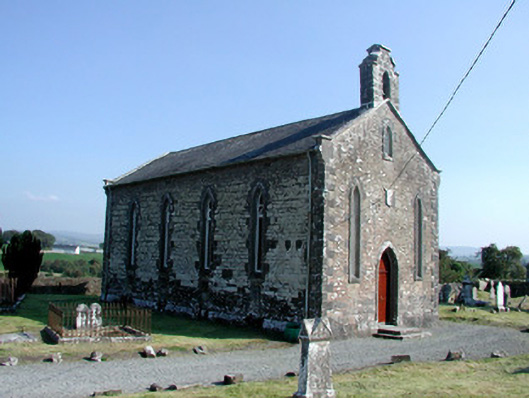 Saint Kieran's Church (Seirkieran)church/chapel · 51 yd
 RampartsCastle, motte · 116 yd
 HawthornHawthorn · 420 yd
 Saint Kieran's WellSpring · 579 yd
 Ballymooney Castle in RuinsHouse, fortified house · 1238 yd
 Derrykeel WoodWood · 1.4 mi
 Drummin HillMountain / peak · 2.3 mi
 Birr Heritage CentreMuseum · 5.1 mi
 James Franklin FullerMemorial · 5.3 mi
Other information
Photo: Credit not shown in the picture search · Rights wording not checked; contact us if this picture should be removed