What is recorded here
Irregular shaped graveyard (OF039-003007-) with poorly preserved church (OF039-003005-) with gun turret at SE angle, base of round tower (OF039-003003-) at NW angle, base of high cross (OF039-003002-), cross-slabs, architectural fragments, 19th-century C of I church and medieval earthworks of a deserted medieval settlement enclosing graveyard from S through W to N and low motte (OF039-003----) to SW, all of which is contained within the impressive remains of a bivallate ecclesiastical enclosure (OF039-003001-). Founded by St. Kieran the elder in the fifth century (ITA Survey 1943). The SE angle of the graveyard wall enclosing the graveyard of Seir Kieran appears to incorporate the fragment of a medieval building. Possible doorway opening visible in the S wall near the SE angle of the graveyard. This building appears to have been reused as a later 18th or 19th century mausoleum.
Compiled by: Caimin O'Brien.
Date of upload: 23 May 2011
The monument record does not grant public access. Check the route and ask the landowner before entering private land.
- What survives
- Recorded monument
Places near here
 Burying GroundGraveyard · 35 yd
 Base of CrossCross, High cross · 40 yd
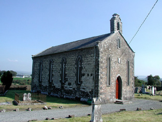 Saint Kieran's Church (Seirkieran)church/chapel · 49 yd
 RampartsCastle, motte · 117 yd
 HawthornHawthorn · 411 yd
 Saint Kieran's WellSpring · 552 yd
 Ballymooney Castle in RuinsHouse, fortified house · 1262 yd
 Derrykeel WoodWood · 1.4 mi
 Drummin HillMountain / peak · 2.3 mi
 River WalkWalking route · 4.9 mi
 Birr Heritage CentreMuseum · 5.1 mi