Overview
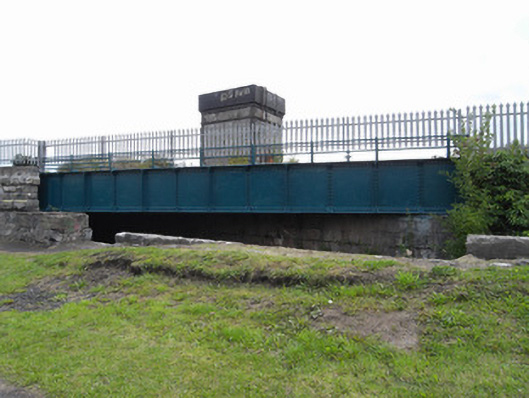
bridge — Moyle Road is recorded as bridge in Dublin. Single-span railway bridge, erected c.1864, carrying Dublin to Sligo railway over Royal Canal. Flat-deck railway bridge with steel girder supports and riveted steel parapet to either side.
Why it was built
The saved account records: Single-span railway bridge, erected c.1864, carrying Dublin to Sligo railway over Royal Canal.
People and work
The saved account records: Flat-deck railway bridge with steel girder supports and riveted steel parapet to either side.
How it changed
The saved account records: Deck supported on coursed tooled limestone canal lock walls with rock-faced limestone walls to northeast supporting deck across pedestrian passageway surmounted by robust piers with limestone ashlar rock-faced base and coping.
What survives
The official record fixes the place and calls it bridge. It does not provide a full list of finds or a current condition report, so visible and buried remains are not guessed.
Why it mattered
bridge — Moyle Road matters for the exact reasons given in its official assessment, rather than merely because it is an old structure. The source records: A well-constructed steel railway bridge from the mid-nineteenth-century. Together with the canal lock beneath it forms an interesting composition at the intersection of two major developments in Ireland’s infrastructure, the canal system and the railway system. The bridge is part of a further collection of structures on the Dublin to Sligo rail route. Both elements display good quality masonry and engineering over the course of a century and remain as reminders of the role of infrastructure in the modernising of Dublin and the country as a whole. This explains what the place adds to local life, the street or the surviving built history.
History checked 15 August 2026 against the named sources below.
Places near here
- 7th Lock, Royal Canalbuildingunder 0.1 miles
- Quarry in Unknown Townlandmonument0.3 miles
- Wayside shrine — N9032450653monument0.3 miles
- Marian Shrinemonument0.3 miles
- Ardstraw House — Finglas Roadbuilding0.3 miles
- Church of the Most Precious Blood — Faussagh Avenuebuilding0.3 miles
- Unknown Destinationattraction0.3 miles
- Saint Finbarr's Boys National School — Kilkieran Roadbuilding0.3 miles
- 1981 Hunger Strikersmemorial0.3 miles
- Hello Cabraattraction0.3 miles
- 1916 Risingmemorial0.4 miles
- Tolka Lodge — Glasnevin Woodsbuilding0.4 miles
Add the human story, a picture, a first-hand message or a missing place.
Earn 5 points after the picture is checked and accepted.
Add a pictureAdd its storyTalk or ask a questionAdd a new placeThis official record and map point do not grant access. Most recorded buildings are privately owned; view them only from public ground unless the owner allows entry.
Conversation about this place
Questions and messages sit beneath the source record. They are checked before appearing.
No questions or messages yet.
Ask a question or join the conversation