What is recorded here
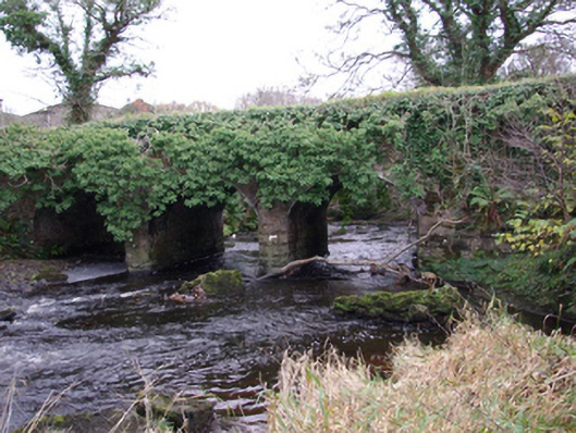
Triple-arched bridge carrying road over the Oily River, built or rebuilt c. 1860, having rock-faced ashlar V-profile cutwaters to central piers. Segmental-headed arches having rock-faced stone voussoirs with dressed margins; squared rubbles tone construction to arch barrels. Coursed and squared rubble stone construction to spandrels and abutments. Coursed rubble stone construction to parapets with rock-faced coping over. Side elevations now largely obscured with vegetation. Tarmacadam deck with grass verges. Stone weir adjacent to bridge. Located to the north-west of Dunkineely and to the east of Killybegs. Located just to the north of where the Oily River discharges into McSwyne’s Bay.
This well-built triple-arched road bridge retains its early character and form, and is an appealing feature in the scenic landscape to the west of Dunkineely. It is robustly-constructed in local rubble stone masonry, and its continued survival and use stands as testament to the quality of its original construction, and of the skill of the masons involved. The good quality rock-faced voussoirs to the arch and the rock-faced construction to the central cutwater are of a high standard, which helps to elevate this bridge above many of its contemporaries in Donegal. The use of rock-faced masonry is a feature of the many bridges that were built or altered by the Board of Works during the mid-to-late nineteenth century, and particularly between c. 1847 - 60, suggesting that this bridge originally dates to this time (not depicted on Ordnance Survey first edition six-inch map of 1836). However, a bridge is depicted here in 1837 (Ordnance Survey first edition six-inch map sheet) so this bridge may contain earlier fabric. This fine bridge is an integral element of the built heritage of the local area, and is a feature of some picturesque qualities in the scenic landscape. It is one of two fine triple-arch bridges over the Oily River at this location (railway bridge – see 40909833).
This does not grant access. Most recorded buildings are privately owned; view them only from public ground unless the owner allows entry.
Places near here
 Church of SS Joseph & Conalchurch/chapel · 231 yd
 Wych ElmWych Elm · 585 yd
 Bruckless Househouse · 626 yd
 Bruckless Enclosure near Bruckless HouseEnclosure · 648 yd
 Aighan Ecclesiastical Enclosure and Holy WellEcclesiastical enclosure · 702 yd
 European BeechEuropean Beech · 1253 yd
 Killaghtee Old Church GraveyardGraveyard · 1.0 mi
 Bawn in Rahan NearBawn · 1.6 mi
 Bawn in KillybegsBawn · 2.0 mi
 Rashenny PointHeadland · 2.2 mi
 Carntullagh HeadHeadland · 2.6 mi
 Rotten IslandIslet · 2.6 mi
Other information
Photo: National Inventory of Architectural Heritage · Website use allowed for educational or private purposes with source credit