Overview
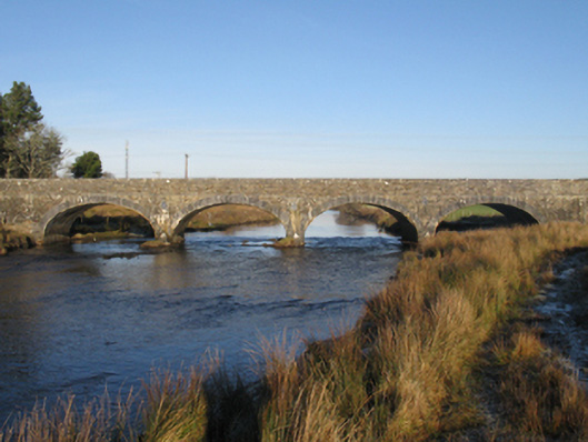
Bellacorick Bridge is recorded as bridge in Mayo. Four-arch bridge over river, built 1820-1 Part repointed coursed cut-limestone walls centred on tooled limestone ashlar rounded triangular cutwaters having domed pyramidal capping with cut-limestone stringcourses supporting parapets having tooled cut-limestone coping centred on rope twist-detailed cut-limestone date stone ("1820").
Why it was built
The saved account records: Four-arch bridge over river, built 1820-1
People and work
The saved account records: Part repointed coursed cut-limestone walls centred on tooled limestone ashlar rounded triangular cutwaters having domed pyramidal capping with cut-limestone stringcourses supporting parapets having tooled cut-limestone coping centred on rope twist-detailed cut-limestone date stone ("1820").
How it changed
The saved account records: Series of four elliptical arches between cast-iron "Pattress" tie plates with drag edged tooled limestone ashlar voussoirs.
What survives
The saved account records: Sited spanning Owenmore River with unkempt banks to river.
Why it mattered
Bellacorick Bridge matters for the exact reasons given in its official assessment, rather than merely because it is an old structure. The source records: A bridge representing an important component of the early nineteenth-century civil engineering heritage of County Mayo with the architectural value of the composition, one designed by William Bald (c.1789-1857) 'BY ORDER OF THE GRAND JURY...RIGHT HON DENIS BROWNE [1763-1828] FOREMAN', confirmed not only by the construction in a multi-toned limestone with blue-grey dressings producing a mild polychromatic palette, but also by the elegant "sweep" of the arches making a pleasing visual statement at a crossing over the Owenmore River: meanwhile, a much-weathered benchmark remains of additional interest for the… This explains what the place adds to local life, the street or the surviving built history.
History checked 15 August 2026 against the named sources below.
Places near here
- Oweninny Visitor Centreviewpoint0.9 miles
- Cist in Tawnaghmore (erris By.)monument1.6 miles
- Indicated — Derry Lowermonument1.8 miles
- Catholic Church of Our Lady — Ballymonnellybuilding2.1 miles
- Road — road/trackway in Altnabrockymonument2.5 miles
- Barrow — unclassified in Altnabrockymonument2.6 miles
- Fairy fort / stone ringfort in Corvoderrymonument2.7 miles
- Standing stone in Dooleeg Moremonument3.4 miles
- Inscribed stone in Largan Begmonument3.4 miles
- Wedge tomb in Largan Begmonument3.4 miles
- Deel Bridge — DERRY UPPER, LACKALUSTRAUNbuilding3.6 miles
- Grave Yard — Largan Begmonument3.6 miles
Add the human story, a picture, a first-hand message or a missing place.
Earn 5 points after the picture is checked and accepted.
Add a pictureAdd its storyTalk or ask a questionAdd a new placeThis official record and map point do not grant access. Most recorded buildings are privately owned; view them only from public ground unless the owner allows entry.
Conversation about this place
Questions and messages sit beneath the source record. They are checked before appearing.
No questions or messages yet.
Ask a question or join the conversation