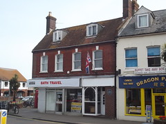
What is recorded here
This blue commemorative plaque records: At the entrance to the town at this point stood the ancient stone gatehouse known as THE BARGATE thought to date from the 12th century, which straddled and constricted the High Street, and was removed c. 1744 by order of the Mayor Recorded plaque organisation: Christchurch Local History Society.
The Bargate was an ancient stone gatehouse dating from the 12th century that served as a significant entry point to Christchurch, symbolizing medieval urban fortification and civic control until its removal in the mid-18th century.
A plaque record does not grant entry to a building or private land. View it from a public place unless permission is clearly given.
Places near here
 Drinking fountain and cattle troughListed building · 101 yd
 MillhamsWood · 266 yd
 Ducking StoolHeritage attraction · 294 yd
 Electricity Museum (former Christchurch Power Station)Listed building · 296 yd
 StocksHeritage attraction · 336 yd
 Christchurch CastleArchaeological place · 361 yd
 Pre-Conquest monastery, early Christian cemetery, Augustinian priory and a motte and bailey castle at ChristchurchScheduled monument · 500 yd
 Stour RoadVisitor information · 507 yd
 Christchurch: Rotary Club wishing wellOld or holy well · 638 yd
 Christchurch, boundary stoneMonument or public art · 1326 yd
 Visitor Centre Stanpit Marsh Local Nature ReserveVisitor information · 1566 yd
 Southbourne BeachBeach / strand · 1.3 mi
Other information
Photo: Elliott Brown · CC BY-SA 2.0