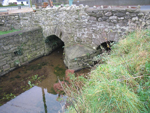
What is recorded here
Two-arch rubble stone road bridge over stream, c.1825. Widened, c.1975, accommodating two-span section to south. Random rubble stone walls with squared rubble stone triangular cut-water to pier having rendered coping, rubble stone battlemented coping to parapet, and unpainted rendered wall to south. Pair of round arches with dressed rubble stone voussoirs, rubble stone soffits, and pair of reinforced concrete flat spans to south. Sited spanning stream with grass banks to stream having random rubble stone retaining walls.
Forming a pleasant, if subtle feature in the local landscape a modest-scale bridge represents the technical or engineering achievements of two centuries as identified by the construction of the arches and spans.
This does not grant access. Most recorded buildings are privately owned; view them only from public ground unless the owner allows entry.
Places near here
 Carrigeen Creamerycreamery · 743 yd
 Church in Aglish SouthChurch · 1000 yd
 Enclosure in DungoolyEnclosure · 1201 yd
 Enclosure in BallincurraEnclosure · 1.1 mi
 Corluddy Castle (in Ruins)Castle, tower house · 1.4 mi
 Native Woodland Trust:Grace Dieu ReserveWood · 2.1 mi
 CastleCastle, unclassified · 2.2 mi
 Ballynaboley WoodForest · 2.5 mi
 Waterford & Suir Valley RailwayHeritage attraction · 3.0 mi
 Mount Congreve GardensHeritage attraction · 3.1 mi
 Ballyscanlon HillMountain / peak · 8.2 mi
 St. Martin's WellSpring · 8.9 mi
Other information
Photo: National Inventory of Architectural Heritage · Website use allowed for educational or private purposes with source credit