What is recorded here
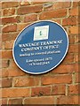
The public map records this plaque for Wantage Tramway. Its recorded inscription reads: Wantage Tramway Company Office leading to covered platform. Line opened 1875 – Closed 1945
The Wantage Tramway, operational from 1875 to 1945, was a vital local transportation link that facilitated economic activity and daily travel in Oxfordshire, reflecting the broader impact of light railway systems on rural British communities during the late Victorian and early 20th centuries.
A plaque record does not grant entry to a building or private land. View it from a public place unless permission is clearly given.
Places near here
 2, Grove StreetListed building · 74 yd
 Statue of King Alfred in Wantage Market SquareMonument or public art · 113 yd
 King Alfred StatueMonument · 115 yd
 The Bear HotelListed building · 123 yd
 King Alfred Statue, Wantage Marketplace.Monument or public art · 127 yd
 Willow Walk Nature ReserveNature reserve · 567 yd
 Chain Hill cemetery, WantageChurch, cross or graveyard · 692 yd
 Milestone 1 mile east of WantageMonument or public art · 1571 yd
 Wellington GateMemorial · 1.1 mi
 Windmill HillMountain / peak · 1.2 mi
 Arnhill PlantationWood · 1.7 mi
 Castle HillMountain / peak · 2.3 mi
Other information
Photo: Fly on Geograph · CC BY-SA 2.0