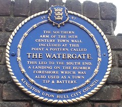
What is recorded here
This blue commemorative plaque records: The southern arm of the 14th century town wall included at this point a postern called The Watergate. This led to the South End, a landing on the Humber foreshore which was also used as a town tip & battery. Recorded plaque organisation: Kingston upon Hull City Council.
The Watergate was a postern gate in Hull's medieval town walls, leading to the South End on the Humber foreshore, which served multiple purposes including waste disposal and military defense, reflecting the site's historical importance for both civilian and strategic activities.
A plaque record does not grant entry to a building or private land. View it from a public place unless permission is clearly given.
Places near here
 Central Dry Dock/ Sand Southend WharfListed building · 47 yd
 Tidal Surge Barrier, River HullListed building · 81 yd
 Recycling sculpture, HullPublic sculpture · 94 yd
 'Truelove' sculpture, HullPublic sculpture · 99 yd
 Victoria Pier Information SignVisitor information · 264 yd
 Neil Hadlock sculptureMonument · 446 yd
 Land of Green GingerMemorial · 477 yd
 Seamen's memorialMemorial · 479 yd
 Siege of Hullsiege · 512 yd
 Beverley GateArchaeological place · 620 yd
 Millennium Milepost HullVisitor information · 724 yd
 Anonymous Postbox, Queen StreetOld post box · 127 yd
Other information
Photo: Chris Hill · CC BY 2.0