Overview
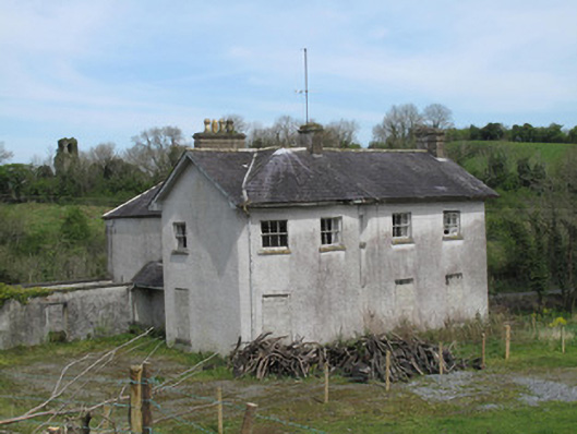
The Rectory — Killeevan is recorded as rectory/glebe/vicarage/curate's house in Monaghan. Detached five-bay two-storey T-plan rectory over half-basement, built c.1800, having entrance under lean-to canopy to west elevation of three-bay return. Bar of 'T' is five-bay south block, having three-bay bow to west end.
Why it was built
The saved account records: Two-storey three-bay outbuilding to rear of house, with single-storey lean-to east elevation, pitched slate roof, red brick chimneystack, cast-iron rainwater goods and red brick eaves course, random rubble stone walls, with squared stone block-and-start quoins, gauged-brick square-headed window openings having red brick surrounds, tooled masonry sills and timber fittings, and gauged-brick three-centred arches to east and west elevations with double-leaf timber battened door to west elevation.
People and work
The saved account records: Detached five-bay two-storey T-plan rectory over half-basement, built c.1800, having entrance under lean-to canopy to west elevation of three-bay return.
How it changed
The saved account records: Bar of 'T' is five-bay south block, having three-bay bow to west end.
What survives
The saved account records: Cast-iron fan-railings on stone plinth walls having render capping.
Why it mattered
The Rectory — Killeevan matters for the exact reasons given in its official assessment, rather than merely because it is an old structure. The source records: The different footprint of this building on the early OS maps indicates that it may have been rebuilt or partly demolished. The front of the building is enlivened by a bowed projection, which appears to have been placed centrally on the 1908 OS map. Although it has been significantly altered, this building retains much original form and fabric and forms part of a group with the nearby Saint Laeban's Church. This explains what the place adds to local life, the street or the surviving built history.
History checked 15 August 2026 against the named sources below.
Add the human story, a picture, a first-hand message or a missing place.
Earn 5 points after the picture is checked and accepted.
Add a pictureAdd its storyTalk or ask a questionAdd a new placeThis official record and map point do not grant access. Most recorded buildings are privately owned; view them only from public ground unless the owner allows entry.
Conversation about this place
Questions and messages sit beneath the source record. They are checked before appearing.
No questions or messages yet.
Ask a question or join the conversation