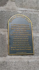
What is recorded here
This black commemorative plaque records: Sugar House Lane. In 1776 a Sugar House was established here, where raw sugar from the Americas was refined for resale. This was one of several businesses in Aberdeen which were involved in the trans-Atlantic trade of slave-produced goods. Sugar House Lane was eventually formed in the ground which once belonged to the Sugar House Company. Recorded plaque organisation: Aberdeen City Council.
The Sugar House in Aberdeen was a key site for refining raw sugar from the Americas, reflecting its involvement in the trans-Atlantic trade that relied on slave labor. The establishment and subsequent street named after it, Sugar House Lane, serve as reminders of Aberdeen's role in the historical trade of goods produced through slavery.
A plaque record does not grant entry to a building or private land. View it from a public place unless permission is clearly given.
Places near here
 Aberdeen, Waterloo Quay, Flour Mill and Cereal FactoryFlour Mill (19th Century) · 26 yd
 Aberdeen Harbour, Victoria Dock, Waterloo QuayQuay (period Unassigned) · 109 yd
 Aberdeen, Saint Clement Street, East Saint Clement's Church, Hall and ChurchyardBoundary Wall (17th Century), Burial Ground (19th Century), Chapel (19th Century), Church (19th Century), Church Hall (19th Century) · 141 yd
 George Davidsone MemorialMemorial · 150 yd
 Aberdeen Harbour, Victoria DockDock (period Unassigned) · 198 yd
 Theatre LaneVisitor information · 585 yd
 Aberdeen, Queen's LinksNo Class (event) (period Unassigned) · 588 yd
 Aberdeen CastleCastle (medieval), Motte (medieval)(possible) · 601 yd
 Aberdeen, Castle StreetNo Class (event) (period Unassigned) · 655 yd
 Bob CooneyMemorial · 675 yd
 Grampian Eye Big Wheel At Aberdeen BeachBeach · 688 yd
 Aberdeen Maritime MuseumMuseum · 787 yd
Other information
Photo: Jez Nicholson · CC BY-SA 2.0