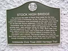
What is recorded here
This green commemorative plaque records: Stock High Bridge. For centuries the water of Stock Ghyll made this the busy industrial centre of Ambleside. By the 10th century Irish-Norse settlers had established small farmsteads on the rocky knoll beyond the old lake-side Roman settlement. From the 14th century their descendants used the beck's water power to work simple mills grinding grain; later washing, fulling and weaving wool. The first mill was established in 1335; the last in 1793. Much later, from local coppiced wood, these mills crushed bark to make tannin for the curing of skins and produced millions of bobbins for the Lancashire cotton industry. The ancient Hallicar ford over the Stock Ghyll was probably nearby. North Road was the coaching road through Ambleside before the turnpike road was built in 1833. Recorded plaque organisation: Ambleside Civic Trust.
Stock High Bridge marks a historically significant industrial area in Ambleside where water power from Stock Ghyll supported various mills for grain grinding, wool processing, tanning, and bobbin production from the 14th to the late 18th century. The site also features historical connections to Irish-Norse settlers and ancient transportation routes like the Hallicar ford and North Road.
A plaque record does not grant entry to a building or private land. View it from a public place unless permission is clearly given.
Places near here
 Ghyll SideListed building · 32 yd
 Market CrossMemorial · 45 yd
 Golden Rule HotelListed building · 101 yd
 Ambleside Great War MemorialMemorial · 394 yd
 Tree sculpture in Rothay ParkPublic sculpture · 429 yd
 Turning Point Sculpture, Rothay Park, AmblesidePublic sculpture · 580 yd
 Stock Ghyll Woods, Path Down from the WaterfallWaterfall · 618 yd
 Thistly WoodWood · 721 yd
 Waterfall at Stockghyll ForceWaterfall · 780 yd
 Crow How WoodWood · 1015 yd
 Main GateVisitor information · 1316 yd
 The Heart of Ambleside Roman FortVisitor information · 1328 yd
Other information
Photo: flipflopnick · CC BY 2.0