
What is recorded here
Samphire Island is a small islet in County Kerry, Ireland. It sits within Tralee Bay, a body of water enclosed from the Atlantic by the Maharee spit. The islet belongs to the same coastal landscape as Fenit village, where a harbour, marina and fishing port still operate. The bay has long exposed people to arrival, departure and danger, from Spanish soldiers taken in 1588 to emigrants carried away by sailing ships. Samphire Island may have offered little more than rock, seaweed and a place to mark the water, but even a small islet can belong to a larger story of movement and memory.
Samphire Island is recorded as a islet in County Kerry. Its open map record supplies this location and any linked names or public references.
Samphire Island, located off the coast of County Kerry, is a small islet that has historically been associated with coastal communities reliant on fishing and maritime trade. The island is notable for its natural rock formations and the presence of samphire, a salt-tolerant plant used in traditional cuisine and medicine.
Places near here
 Saint BrendanMemorial · 206 yd
 Fenit BeachBeach / strand · 775 yd
 Enclosure in Fenit WithoutEnclosure · 1229 yd
 Samphire Island LittleIslet · 1486 yd
 Little Samphire Island LighthouseLighthouse · 1489 yd
 Kilfenora Church (site of)Archaeological place · 1.2 mi
 Church in KilfenoraChurch · 1.2 mi
 Derrymore Island Nature ReserveNature reserve · 1.8 mi
 Fenit Castle (in ruins)Castle, tower house · 2.0 mi
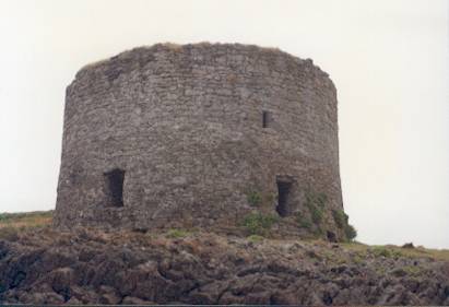 Barrow Round Castle (in ruins)Castle, tower house · 2.2 mi
 CloghnacroustaNamed rock · 3.0 mi
 Tralee BayBay · 3.3 mi
Other information
Photo: Credit not shown in the picture search · Rights wording not checked; contact us if this picture should be removed