What is recorded here
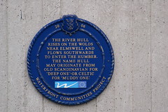
This blue commemorative plaque records: The River Hull rises on the Wolds near Elmswell and flows southwards to enter the Humber. The name Hull may orginate from old Scandinavian for 'Deep One' or celtic for 'Muddy One'. Recorded plaque organisation: Waterfront Communities Project.
The River Hull is a navigable waterway in East Yorkshire, England, playing a crucial role in the development of Kingston upon Hull as a port city by providing access to the Humber Estuary and beyond. Its name possibly derives from Old Scandinavian meaning 'Deep One' or Celtic for 'Muddy One', reflecting historical linguistic influences in the region.
A plaque record does not grant entry to a building or private land. View it from a public place unless permission is clearly given.
Places near here
 Tidal Surge Barrier, River HullListed building · 13 yd
 'Truelove' sculpture, HullPublic sculpture · 40 yd
 Recycling sculpture, HullPublic sculpture · 60 yd
 Central Dry Dock/ Sand Southend WharfListed building · 95 yd
 Victoria Pier Information SignVisitor information · 311 yd
 Land of Green GingerMemorial · 490 yd
 Siege of Hullsiege · 500 yd
 Neil Hadlock sculptureMonument · 506 yd
 Seamen's memorialMemorial · 514 yd
 Beverley GateArchaeological place · 656 yd
 Millennium Milepost HullVisitor information · 766 yd
 Anonymous Postbox, Queen StreetOld post box · 190 yd
Other information
Photo: Chris Hill · CC BY 2.0