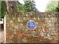
What is recorded here
This blue commemorative plaque records: This village is recorded in the Domesday Book as Hanstede 1086 Recorded plaque organisation: Hampstead Norreys Heritage.
This village, recorded as Hanstede in the Domesday Book of 1086, provides evidence of its existence and landholding structure under Norman rule post-1066.
A plaque record does not grant entry to a building or private land. View it from a public place unless permission is clearly given.
Places near here
 Church of St. MaryListed building · 13 yd
 Pump Close By South Corner of Barn in Church StreetListed building · 57 yd
 Hampstead Norreys MotteVisitor information · 120 yd
 Folly HillWood · 631 yd
 Perborough CastleScheduled monument · 1.3 mi
 Little Ridge CopseWood · 1.9 mi
 St Frideswide's WellMonument · 2.3 mi
 Grimsbury Hill FortArchaeological place · 2.7 mi
 Grimsbury CastleScheduled monument · 2.8 mi
 Battle of AshdownMajor battlefield · 3.6 mi
 The Ridgeway National TrailVisitor information · 3.9 mi
 Thurle DownMountain / peak · 4.2 mi
Other information
Photo: Bikeboy on Geograph · CC BY-SA 2.0