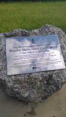
What is recorded here
This brushed metal commemorative plaque records: Brigadier Martin Hotine CMG CBE RE 17 June 1898-12 November 1968 Head of Trigonometrical and Levelling Division, Ordnance Survey, 1934-1939, Designer of the Ordnance Survey Trigonometrical Pillar, 1935, Founding Director, Directorate of Overseas Surveys, 11 March 1946-10 October 1963 Recorded plaque organisation: Ordnance Survey.
Brigadier Martin Hotine was a British military officer and cartographer who significantly contributed to surveying techniques, notably designing the Ordnance Survey Trigonometrical Pillar in 1935 and founding the Directorate of Overseas Surveys in 1946.
A plaque record does not grant entry to a building or private land. View it from a public place unless permission is clearly given.
Places near here
 Yew Tree FarmhouseListed building · 146 yd
 War MemorialMemorial · 228 yd
 Home CovertWood · 469 yd
 Electricity sub-station, Nursling industrial estateHeritage place · 867 yd
 Lower Test Nature ReserveNature reserve · 1453 yd
 Sculpture, OS HQPublic sculpture · 1694 yd
 St Winfrid, Totton: ancient stoneAncient stone or rock art · 1.4 mi
 Totton Railway Station Enterance SignVisitor information · 1.5 mi
 Toot HillMountain / peak · 1.8 mi
 Testwood Lakes CentreVisitor information · 1.8 mi
 Old Milestone by the A36, Sharves Hill, Netley Marsh parishMonument or public art · 1.9 mi
 Eling Tide Mill Experience Visitor CentreMuseum · 1.9 mi
Other information
Photo: Jez Nicholson · CC BY-SA 2.0