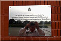
What is recorded here
This brushed metal commemorative plaque records: The trees in the avenue nearby were planted by present and former Directors General and Chief Executives to commemorate the completion and occupation of these offices by Ordnance Survey 2010-11 on the occasion of the 220th anniversary of the founding of Ordnance Survey 21 June 2011 Recorded plaque organisation: Ordnance Survey.
The trees commemorate the completion and occupation of new offices by Ordnance Survey in 2010-11, marking the organization's 220th anniversary on June 21, 2011. Ordnance Survey is historically important as the national mapping agency of Great Britain, established to create detailed maps for military and later public use.
A plaque record does not grant entry to a building or private land. View it from a public place unless permission is clearly given.
Places near here
 Yew Tree FarmhouseListed building · 136 yd
 War MemorialMemorial · 238 yd
 Home CovertWood · 470 yd
 Electricity sub-station, Nursling industrial estateHeritage place · 885 yd
 Lower Test Nature ReserveNature reserve · 1453 yd
 Sculpture, OS HQPublic sculpture · 1672 yd
 St Winfrid, Totton: ancient stoneAncient stone or rock art · 1.5 mi
 Totton Railway Station Enterance SignVisitor information · 1.5 mi
 Toot HillMountain / peak · 1.8 mi
 Testwood Lakes CentreVisitor information · 1.8 mi
 Eling Tide Mill Experience Visitor CentreMuseum · 1.9 mi
 Old Milestone by the A36, Sharves Hill, Netley Marsh parishMonument or public art · 1.9 mi
Other information
Photo: Adrian Cable on Geograph · CC BY-SA 2.0