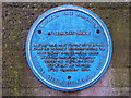
What is recorded here
This blue commemorative plaque records: St Leonard's Square. Once a focal point for the old town which before the Industrial Revolution occupied the ridge towards Rochdale. Nearby street names - High Street and Cheapside - identify the old town. Cottage silk weaving was practised in the surrounding area. Recorded plaque organisation: Middleton Civic Association.
St Leonard's Square served as a central gathering place in the pre-Industrial Revolution old town, situated on the ridge towards Rochdale, reflecting the area’s historical importance in cottage silk weaving and traditional commerce evident from nearby street names like High Street and Cheapside.
A plaque record does not grant entry to a building or private land. View it from a public place unless permission is clearly given.
Places near here
 Church of St LeonardListed building · 38 yd
 Warwick Mill Including Adjoining RailingsListed building · 717 yd
 Alkrington WoodForest · 1.2 mi
 Welcome to MiddletonVisitor information · 1.6 mi
.jpg?width=1280) Chadderton CemeteryRegistered park or garden · 2.0 mi
Chadderton CemeteryRegistered park or garden · 2.0 mi Bailey's WoodWood · 2.0 mi
 War MemorialMonument · 2.4 mi
 Tandle Hill ObeliskMonument or public art · 2.4 mi
 Tandle HillMountain / peak · 2.4 mi
 Boundary StoneMonument or public art · 2.6 mi
 Naden Brook, Higher Clough waterfallWaterfall · 4.5 mi
 Waterfall on Naden BrookWaterfall · 4.5 mi
Other information
Photo: Alexander P Kapp on Geograph · CC BY-SA 2.0