What is recorded here
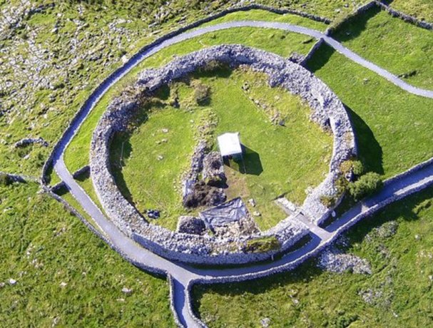
Indicated is a square cashel on a Clare limestone plateau where a ravine drops fifty metres to the west. Its broken wall still holds a ghost house and two corner cells, proving the site served living people rather than fleeing fairy kings.
On a plateau of limestone with a thin grass cover, and a ravine c. 50m to the W. Within a multiperiod field system (CL009-255----). This square cashel (int. dims. 32.3m NE-SW; 32.2m NW-SE) is defined by a stone wall (Wth c. 1.4m; int. H 0.4-0.8m; ext. H 0.5m). The outer wall-face of large horizontally laid stones can be traced nearly all the way around, but the wall is largely obscured by stone spill (total Wth 2-3m). There is a possible entrance (Wth 1.5m) at the NE, defined by two upright stones. A later drystone wall overlies this side of the cashel wall. At SW the cashel wall has been re-built in places as a double-faced wall (Wth c. 1m; max. ext. H 2.5m). The remains of a house (CL009-168002-) lie in the centre of the cashel. Later cells are built in two of the internal corners, one (int. dims. 4m NW-SE; 3.2m NE-SW) in the N corner defined by a double-faced wall and another in the S corner (int. dims. 7m NE-SW; 6m NW-SE; max. H 0.8m) with a curvilinear wall in which stones are laid transversely.
Compiled by: Mary Tunney and Conn Herriott
Date of upload: 6 July 2022
The monument record does not grant public access. Check the route and ask the landowner before entering private land.
- What survives
- Recorded monument
Places near here
 Poulnabrone - Burren GeositeVisitor information · 534 yd
 Poulnabrone DolmenHeritage attraction · 568 yd
 Portal tomb in PoulnabronePortal tomb · 569 yd
 The Portal TombVisitor information · 585 yd
 CaherlisnanroumFairy fort / stone ringfort · 607 yd
 Gleansleade Castle (in ruins)Castle, tower house · 813 yd
 CaherconnellHeritage attraction · 893 yd
 Caherconnell Stone FortRuins · 1056 yd
 Cave of the Wild HorsesCave · 1432 yd
 PoulnabroneMemorial · 1.1 mi
 Carran Church (in ruins)Church · 1.9 mi
 Site of Ballymurphy CastleCastle, tower house · 2.2 mi