Add a picture, leave a message or tell me about a missing place.
Earn 5 points after the picture is checked and accepted.
Add a pictureShare what you foundAdd a new placeWhat is recorded here
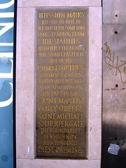
This stone commemorative plaque records: This stone marks the site of one of the ancient common lanes leading from the staithes into the city along the south eastern side of the Roman fortress. Formerly a ward boundary, the old lane also divided the parishes of Saint Martin Coney Street & Saint Michael Spurriergate the boundaries of which now run through these premises.
A plaque record does not grant entry to a building or private land. View it from a public place unless permission is clearly given.