Add your own picture and explain the route, parking, gates, paths or landmarks that help people find it.
Earn 5 points after the picture is checked and accepted.
Add your photo and local directionsShare what you foundWhat is recorded here
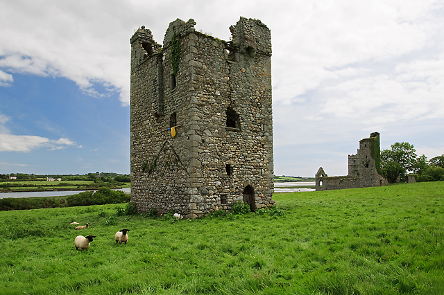
Situated on the flood-plain of the conjoined N-S Owenduff and Corock rivers, with the stream c. 100-140m to the E. This is known as the Black Castle, and is attributed to the FitzHenrys (Hore 1900-11, vol. 2, 216), who also had a castle at Kilcavan (WX046-001----) in Bargy, c. 3.5km to the E, although the FitzHenrys are not directly associated with Clonmines in any documents.
This is a rectangular tower (ext. dims 9.8m E-W; 8.1m N-S) of five floors, surviving to the wall-walk, with good granite quoins and a base-batter. A pointed doorway (Wth 1.14m; H 2.04m) of dressed granite with undressed voussoirs towards the S end of the W side is protected by machicolation externally and a murder-hole in the lobby. Where it can be determined all the other doorways are lintelled. The lobby leads directly to the ground floor (int. dims 5.13m E-W; 3.92m N-S) with five embrasures (two in the N wall), but the only lights are double-splayed loops in the E and W walls. From the lobby a mural stairs rises in the S wall, and there is a secondary doorway to the exterior in the S wall at the foot of the stairs. The stairs give access through a lintelled doorway (Wth 0.8m; H 2.1m) to the first floor under the E-W vault, which has a rectangular window in the E and W walls. The floor was supported on corbels in the N and S walls, with a rebate above on all walls.
The stairs continue in the S wall to the SE angle where a damaged doorway (Wth 0.74m) provided access to the second floor (int. dims. 6.3m E-W; 4.34m N-S) over the vault. This floor has a damaged window in an embrasure with seats in the W wall, and a damaged window and robbed fireplace in the N wall. There is a corner chamber (int. dims 2m E-W; 0.86m N-S: H 1.9m) in the thickness of the S wall at the SW angle, and a garderobe (int. dims 1.8m N-S; 0.86m E-W; H 2.2m) at the NE angle in the thickness of the E wall. This is entered through a lintelled doorway (Wth 0.66m; H 1. 85m) in the E wall, while a box-niche from the main chamber accesses the garderobe chute directly for the disposal of waste. A chamber (int. dims 2.53m N-S; 0.85m E-W; H 1.93m) at the S end of the E wall has a spy-hole in the roof through a riser in the mural stairs in the E wall, although this might be damage. There are corbels for the ceiling in the W and N walls with a rebate on the other walls.
The stairs rise in the E wall to the third floor which has windows with seats in the N and S walls, a destroyed fireplace in the N wall and two chambers in the E wall, that at N being a garderobe, and each with its own small light. The ceiling was supported on corbels in the S, W and N walls, with a rebated ledge on the E wall. The chimney flue is supported on corbels on the outer face of the N wall from this floor. The stairs continue in the E wall to the fourth floor which is entered at the N end through a lintelled doorway with cut granite surrounds. The only features on this floor are large destroyed windows in the E and W walls. The stairs continue in the E wall and turn onto the N wall where it emerges on the wall-walk, which doesn’t survive, although the remains of a look out platform are over the stairs housing at NE angle.
Externally there was a building attached to the N (Wth 5.7m) and the flashing-line of its pitched roof can be seen (H 5.33m), but there are no tie-stones. There was a similar building (Wth 6.1m; H 6.3m) attached to the S, and the secondary doorway at the bottom of the tower house stairs, together with two cupboards in the outer face of the tower house wall at ground level, suggests that they might have been in contemporary use. However, a remote sensing survey between the tower house and the house (WX045-012004-)106m to the S, which was conducted to determine if there was a connecting street of houses, was inconclusive, although some indications of floors and wall collapse where encountered (Byrne 1994-5, 72).
The above description is derived from the published 'Archaeological Inventory of County Wexford' (Dublin: Stationery Office, 1996). In certain instances the entries have been revised and updated in the light of recent research.
Compiled by: Michael Moore
Date of upload/revision: 17 July 2007
The monument record does not grant public access. Check the route and ask the landowner before entering private land.