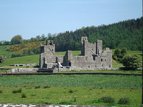
Add your own picture and explain the route, parking, gates, paths or landmarks that help people find it.
Earn 5 points after the picture is checked and accepted.
Add your photo and local directionsShare what you foundWhat is recorded here
National Monument No. 215. After the Anglo-Norman invasion the churches of Fore and their endowments were granted, apparently by Hugh de Lacy, to the Benedictine abbey of St. Taurin at Evreux in Normandy (Gwynn and Hadcock 1970, 106; Orpen 1911-20 ii, 82). This can hardly have occurred before c.1180 while Gwynn and Hadcock (1970, 106) have pointed out that this must have happened before 1185. The endowments of the priory were increased by Walter de Lacy in or before 1210 (Gilbert 1884 ii, 311). Fore was frequently taken into the King's hands, and delivered to a guardian, during the Hundred Years War because it was an alien house dependent on a French abbey. In 1340 the-prior (and guardian), William Tessone, was granted part of the revenues to support himself and five monks, possibly the complement of the priory at this date (Seymour 1934, 64). In 1384 the priory's revenues were committed to the prior John Croys, who was to use them for the support of a chantry consisting of the prior and three chaplains which again may indicate the complement of the priory (Seymour 1934, 66-7). The priory was fortified during the first half of the fifteenth century in response to raids from the Irish who attacked the priory lands in 1423 and again in 1428 (Seymour 1934, 68). William England, prior of Fore from 1418, and William Croys, prior from c.1441, are both credited with having erected "divers castles” for the defence of the priory (Seymour 1934, 68-9; Leask n.d. 21-2: Tresham 1828, 254; Berry 1910, 145). In 1445 parliament removed the priory from Evreux and made it an independent house (Gwynn and Hadcock 1970, 106).
At the dissolution of the monasteries the extent of the priory records "certain castles or towers, and other houses or buildings of stone at present in sufficient repair ....they are very necessary for the defence of the country against the attacks of the wild Irish on the King's subjects" (White 1943, 271). The priory was granted to Matthew King in 1540, Sir William Seyntlowe in 1551, and Christopher Nugent, lord of Delvin in 1567 (White 1943, 271; Morrin 1861, 253; Nicholls 1994, 134). In 1567, Christopher Nugent, lord of Delvin was granted a lease of the ‘site of the priory or manor of Fowre, county Westmeath, lands of Fowre, a lough there called [Logheleyn], lands of Hilton, Carpenterston, Mylcasteltowne, Gilbertston, Rahen, Dromsawry, with a chapel and tithes, Comoylston, Lighill alias, Larkehill by the parts of the Breny, Fayron, Keneleighe, Ratheny, Donamore, Betaghton, Nynche, 13s. 4d. chief rents out of Nenaghe, in the said county, and the customs of the tenants ; the rectories of S. Mary in Fower (WM008-097002-), S. Fekins (WM004-035003-) in Fower, Archidiorum (WM004-035004-) in Fower, Fayron, Faghley, Mayne, Leigheblay, Dromiskille, Ragarf, Oldecastell, and Balmagarvy, in the counties of Meath and Westmeath, and diverse parsonages in the Breny. To hold the possessions of Fower, for 21 years from 1582, at a rent of £175 10s 8d., and maintaining five horsemen’ (Nicholls 1994, 134). In 1578 William Dodd was granted a lease of the ‘site of the abbey of Fower (WM004-035010-), co. Westmeath, and the lands in Fowre, Hilton, Carpenterstowne, Mylcastellton, Gilbertston, Raghin, Dromsawry, Comoylston, Leighill alias Larkehill, Firone, Kilmalighe, Rathenny, Donnamore, Ballynniskerry, Betaughston, the Ninche, and Nenaghe, and the tithes and alterages of the rectories of Fower (WM008-097002-), S. Fekyn (WM004-035003-) in Fower, Archediorum (WM004-035004-) of Fower, Fayron, Faughley, Mayne, Lighblay, Dormiskell, Ragarfett, Oldecastell, and Balmagarvy, counties of Meath and Westmeath. To hold for 5 years. Rent, £140’ (ibid., 479).
Lying to the north of the village of Fore, the priory is situated at the southern end of a knoll, known as Knocknamonaster, which is surrounded by wet ground on all sides except the east. The remains consist of the priory complex and a series of outbuildings, including a dovecot, and earthworks on Knocknamonaster. The buildings are grouped around a rectangular cloister. The church lies to the north, the refectory and kitchen on the south, apartments and other domestic buildings on the east and west. The basic layout of the monastery belongs to the early thirteenth century but it was considerably remodelled in a number of building campaigns during the fifteenth. In general it can be remarked that the size of the monastery contracted during the fifteenth century and new buildings were constructed in order to accommodate to the monastery's changing role. The thirteenth century church was a long narrow building with a chapel on its north side; this was shortened during the fifteenth century by the insertion of a tower at the west end and the blocking of the arches leading to the north chapel, which seems to have fallen into disuse. The original east range probably had a chapter room immediately south of the sacristy but during the fifteenth century this wing was totally remodelled in order to provide domestic apartments and a residential tower was constructed over the sacristy. The thirteenth century cloister enclosed a larger area than its fifteenth century counterpart. A new refectory was constructed in the fifteenth century immediateIy north of the old one, which was then demolished. The west range was also remodelled in the fifteenth century when its upper floor was converted into the monks dormitory.
The Church
This is a narrow building of roughly coursed mixed stone divided into a nave and choir by two rows of steps. The basic fabric is of thirteenth century date but a tower was added at the west end in the fifteenth. The east wall of the choir is lit by three round-headed lancets. These have round rear arches and a wide internal splay terminating in jambs with concave chamfers. The inner sills slope downwards to a moulded stringcourse. The north wall has two round-headed windows, partly rebuilt c.1870, while in the south there is a twin round arched niche for a piscina and aumbry. The plaster on the inside of the niche is painted with a masonry design of rectangles, outlined in red-brown with red rosettes in every second space. Leask (n. d. 12) notes that this design was continued on the wall above the piscina but there is no trace of it now. Above this are two rows of stone corbels, supporters for the roof gutters, at different periods. A door in the south wall leads into the sacristy and provides access to the stair leading to the eastern tower. The north wall of the nave is largely featureless and was rebuilt c. 1870. A door near its west end opened northwards into a narrow rectangular room of which only the foundations survive. The west end is delimited by a tower added in the fifteenth century. This has a stair turret projecting to the north to which access is had directly from the nave. There are four round-headed clearstorey windows in the south wall, one of which is blocked by the south wall of the western tower. Immediately north of the nave are the foundations a chapel which was reached through two arches in the nave north wall but these were obliterated when the modern wall was constructed. Two cross slabs (WM004-035027-; WM004-035028-) are set against the external south wall of the nave. Their find place is not recorded but it is likely from their position that they were found in the cloister and probably represent the burial place of two priors.
West Tower
This four-storied rectangular building with projecting stair-turret was a residential tower. The ground floor has a rectangular splayed window with an almost flat rear arch in the north wall and a blocked-up opening (possibly a window) in the west wall. The west wall itself incorporates parts of the original west gable of the thirteenth century church. The first floor was supported on fluted corbels which project from the north and south walls. Externally the jambs of the original west doo
This remains an important historical record, but the official description says the monument is no longer visible or has been destroyed.
The monument record does not grant public access. Check the route and ask the landowner before entering private land.