Add your own picture and explain the route, parking, gates, paths or landmarks that help people find it.
Earn 5 points after the picture is checked and accepted.
Add your photo and local directionsShare what you foundWhat is recorded here
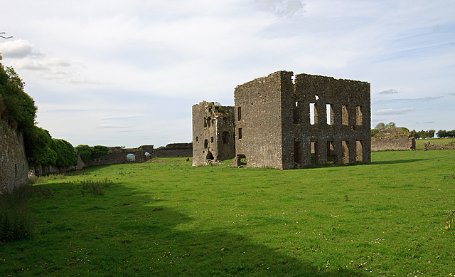
Located in undulating pastureland on a gradual W-facing slope. Described in the Civil Survey (1654-6) as a 'castle in repayre a bawne out of repayre & a windmill in repayre' (Simington 1931, vol. 1, 15). Richard Butler is listed as proprietor in 1640 (ibid.). A late sixteenth/early seventeenth-century four-storey tower house (TN017-009001) with a later house (TN017-009003) added to the SE face in the mid/late seventeenth century. A second pile was added to this and all was modified in the eighteenth-century and incorporated into a large H-plan house, enclosed by an unusually large bawn.
The bawn (dims. 76m NE-SW x 137m NW-SE; int. H 5.3m; ext. H c. 7m), built on bedrock and composed of randomly coursed sandstone rubble, with slight base-batter discernible on the SW wall, is well preserved. There is a natural ledge which extends 7m beyond the bawn wall along the W side. The original entrance was in the SE wall (Wth 3.6m), and the later entrance immediately S of this, with the foundations of the original bawn across the entrance. There was a second original entrance in the NW wall (Wth 2.8m), which is now partially blocked and a smaller opening has been made. The N sector of the bawn is raised 1.35m and is retained by a stone wall which fouls the original NW entrance - this is probably landscaping associated with the eighteenth-century occupation. A large eighteenth-century entrance lies immediately W of this original entrance. Between the original and later eighteenth-century entrance there is a small pedestrian entrance (H 2.5m H; Wth 1.17m) consisting of a round-headed voussoir arch with roughly cut sandstone surrounds. This doorway is not visible internally; the interior appears to have been refaced. There are a number of gun loops in the bawn at both lower and wall-walk level. They are particularly numerous at the N end of the NE wall where there are sixteen horizontal gun-loops at lower bawn level with gun-loops at regular intervals at parapet level. There are four gun-loops in the bawn at the N end of the NW wall, N of the gateways. The NW angle is protected by a corner bartizan resting on five corbels, the super-structure does not survive. A tower projects externally roughly midway along the SW wall. It has been much altered, probably in the eighteenth century, and is partially destroyed but appears to be original. Doorways in the bawn wall on either side of this tower are later insertions. A large fireplace on the internal wall utilises the E wall of this tower. W of this there is a flat-headed doorway (Wth 0.9m; H c. 1.75m), now blocked, with a large stone lintel in a recess in the wall. In the NE wall there is a chimney stack on the wall-walk, effectively blocking it. There is a gun-loop in the bawn wall directly below this stack, with no visible evidence of a fireplace or building adjoining this wall, internally or externally.
The above description is derived from 'The Archaeological Inventory of County Tipperary. Vol. 1 - North Tipperary' compiled by Jean Farrelly and Caimin O'Brien (Dublin: Stationery Office, 2002). In certain instances the entries have been revised and updated in the light of recent research.
Date of upload/revision: 22 September 2008
The monument record does not grant public access. Check the route and ask the landowner before entering private land.