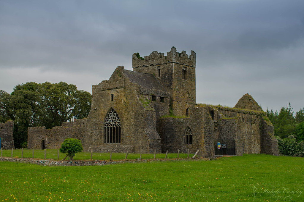
Add your own picture and explain the route, parking, gates, paths or landmarks that help people find it.
Earn 5 points after the picture is checked and accepted.
Add your photo and local directionsShare what you foundWhat is recorded here
Situated on top of natural hillock in undulating terrain, now in the grounds of St Anne's Convent which was formerly the landscaped demesne of Corville House located 80m to W. The Romanesque church (TN012-010001-) of Roscrea is 1.7km to the NW and Monaincha church (TN018-001001-) is 1.7km to the E. The 18th century Corville House was built by the Prittie family and became the residence in the 19th century of John O'Byrne who was created a Count of the Holy Roman Empire by the pope in recognition of his family services to the church. The church in the present townland of Corville is known locally as Sean Ross Abbey and is depicted on the 1837 ed. OS 6-inch map as 'Corbally Abbey'. Today there are no surface remains of the early Christian monastery founded by St. Crónán in the 7th century. The foundation of a church by St Crónán at Sean Ross now Corbally in the 7th century was recorded in the 11th /12th century Latin Life of the saint as following: ‘St Cronan came to east Munster to his own country of Hele (Eile) and halted beside the Bog of Lurga, over aginst the land of the Osraighe (Ossory) which is the western district of Leinster. He built then a church near Loch Cré in which there is a monastery of ever religious monks. The name of the church is Sean Ross. St. Cronan died in 665, after he had transferred his monastery from Sean Ross to Roscrea’ (McNeill 1920, 22). The feastday of St Crónán is celebrated on the 28th of April (Ó Riain 2011, 235)
According to Healy St Crónán 'founded his first monastic cell at a place called Seanross. This old church, though perhaps, subsequently modified and restored, is situated within a few paces of Corville House, near Roscrea, the beautiful residence of Count O'Byrne, who carefully preserves the building from injury or profanation. At this period, however, all the low ground around Corville, towards the railway, was the Locha Cre, or Stagnum Cre, so frequently mentioned in the Lives of the Saints of this district. Seanross was a wooded promontory running into the lake, and it was then so inaccessible and secluded that even Cronan resolved to leave it, and establish his monastery for the convenience of his disciples at the Ross of Cre, which was on the highway from Meath to Munster' (Healy 1912, 523). The monastery at Corbally may have been also known as Inshinamesh which would be a reference to its island like location surrounded by wet poorly drained land.
The Augustinian priory founded at Monaincha (TN018-001001-) around 1140 was moved to Corbally c. 1485 (Gwynn and Hadcock 1970, 153, 167; Stout 1984, 102-4). In 1566 after the dissolution of the monasteries the Crown granted a lease to William O'Carroll and his son John of the site 'of the house of the B.V.M. [Blessed Virgin Mary] of the Island of Life, otherwise called Inchenebeoo [Monaincha], in O'Maghery Country in the lordship of O'Keerroll, the lands of Corbally, Kynnitte....' (Nicholls 1994, 117). In 1568 the church was mentioned in an Inquisition which recorded that there was 'a village called Corballi, wherein the Prior and convent dwelt, and where also was formerly a church that was Parochial as well as Monastic' (Ledwich 1790, 119). In 1586 the dissolved priory and its lands were granted to Sir Lucas Dillon (Nicholls 1994, 750). The Royal Visitation of 1615 described the site as the 'rectoria de Inshinamesh also Corbally. Impropriata ad prioratum Inyshmeo [Monaincha] firmarius Guilemus Dyllon miles' (Murphy 1914, 225). The building was described as 'church and chancel up but shut up against the minister and reserved for masse' (Murphy 1914, 225). The Civil Survey of 1654-56 listed the Earl of Roscommon as the landowner in 1641 which amounted to 1,025 plantation acres of which 325 were arable, 100 pasture and 600 red bog (Simington 1931, 13). The survey recorded that 'upon the sd. lands there is the ruines of an old church' (Simington 1931, 13). The church of Corbally is depicted on the 1654 Down Survey map of the barony of Ikerrin.
In 1840 the church building was described as following; ‘to the southeast of the Town of Roscrea are the ruins of a small Abbey built in the form of a cross. It measures in length from east to west forty four feet six inches [13.56m] and in breadth nineteen feet one inch [5.81m] and the south arm of the cross is eighteen feet six inches [5.63m] in breadth, and the northern is seventeen feet five inches [5.3m] in length from north to south and fourteen feet six inches [4.41m] in width. The east gable is surmounted with a belfry, but so covered with ivy that its form does not appear. The east window is constructed of hammered stones on the inside, where it forms a low arch at top and measures nine feet two inches [2.8m] in height and three feet eleven inches [1.2m] in width; but on the outside it is constructed of chiselled sandstone of a brownish colour and forms two points at the top; it measures on this side four feet six inches [1.37m] in height and one foot ten inches [0.55m] in width and is placed at the height of six feet six inches [1.98m] from the present level of the ground. It was divided into two parts each nine inches [0.22m] in width by a stone mullion which has been taken out. At the distance of two feet eleven inches [0.9m] from the east gable at the south wall has a window which is quadrangular at top on the inside where it measures four feet seven and a half inches [1.4m] in height and two feet nine and a half inches [0.85m] in width; its top is broken off on the outside, so that its height there cannot be ascertained, but its width is seven inches [0.17m]; it is constructed on this side of chiselled sandstone of a brownish colour. This window is half darkened by the east side wall of the lateral apartments, which fact shews that that apartment did not originally belong to the building.
At the distance of eleven feet four inches [3.45m] from the west gable the south wall contains the doorway, which is round headed on both sides. On the inside its head is formed of thin stones not dressed by a chisel or even hammer, but its sides are constructed of chiselled sandstone of a brownish colour; on the outside it is formed of beautiful blocks of chiselled sandstone. It measures seven feet six inches [2.28m] in height and five feet six and a half inches [1.7m] in width on the inside and six feet two inches [1.88m] in height and three feet in width [0.91m] on the outside. It has a rope and channel (term?) on the outside. The west gable contains a quadrangular window placed at the height of ten feet six inches [3.2m] from the ground and measuring on the inside about three feet eight inches [1.1m] in height and two feet six inches [0.76m] in width and on the outside about one foot ten inches [0.55m] in height and seven inches [0.17m] in width; it is formed of hammered sandstone on the inside and of chiselled sandstone on the outside.
The foregoing are all the features on the long part of the house. Let us now return to the south apartment, forming the south arm of the cross. Its east side wall has on the middle of it a window forming a low arch constructed of hammered stones on the inside, where it measures five feet [1.5m] in height and four feet [1.2m] in width, and on the outside where it is constructed of cut limestone in the pointed style, three feet three inches [1m] in height and eight inches [0.2m] in width. Its south gable contains a window forming a round arch constructed of cut limestone and measuring eight feet three inches [2.5m] in height and five feet [1.5m] in width; it is pointed on the outside and divided into four compartments by two mullions, one placed in a perpendicular and the other in a horizontal position; it measures on this outside part five feet four and a half inches [1.63m] in height and one foot eight and a half inches [0.52m] in width. The pointed or upper compartments are two feet eight inches [0.81m] in height and seven and a quarter inche
The monument record does not grant public access. Check the route and ask the landowner before entering private land.