Add your own picture and explain the route, parking, gates, paths or landmarks that help people find it.
Earn 5 points after the picture is checked and accepted.
Add your photo and local directionsShare what you foundWhat is recorded here
National Monument No. 363. Situated on top of a low natural rise of rock outcrop on the S shore of Lough Derg. The castle, known as Terryglass Castle, appears to have been built between 1219 and 1232. In the year 1219 John Marshall (possibly brother of William Marshall Earl of Pembroke) is cited as not having fortified Terryglass (Cal. doc. Ire., no. 913) while by 1237 Maurice Fitzgerald, the Justiciary of Ireland, returned the security of his debts to John Marshall 'seisin of a stone house, being the capital messuage of those lands with its appurtenances, called Tyringlas' (Cal. doc. Ire., no. 2427). These debts which John Marshall owed to the King were first mentioned as early as 1232 (Cal. doc. Ire., no. 1949) and it may have been at this time that the King took seisin of his lands and castle as security against the accrued debts. The castle changed hands several times in the following centuries with Nicholas Dunheued recorded as 'having the guard (warda) of Tyranaglas' in 1275-6 (Leask 1943, 141). In 1289 Theobald le Bottiller owed Richard de Burgo rent of 'the manor, ferry & c. of Tyrneglas' (PRI rep. DK 37, 41) and in 1290 William Marshall was listed as the Lord of Terryglass (Cal. doc. Ire., no. 315). In the Pipe roll of Tipperary for 1301-3 William le Mareschall is cited as having seisin of Tyrnachglas (PRI rep. D.K. 38, 89) and in 1323 Richard de Burgo is listed as tenant of the manor of 'Tyrnagals' (PRI rep. DK 42, 43). By 1334 the castle is described as the 'castle and manor held of the see of Killaloe' along with a 'mill of the town of Tyrdeglas' (Cal. inq. post mortem vol. 7, no. 537). In 1589 James Butler of Grenan was granted the 'Castle Manor or town of Tiraglasse' (Curtis 1943, no. 132).
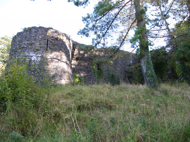
The remains are poorly preserved, surviving one storey high, and were built with roughly coursed limestone rubble with base-batter. The ground plan (which is the same as the other Marshall castles at Carlow, Lea and Ferns) consists of a central rectangular block (dims. 10.7m E-W; 18.1m N-S; wall T 2.8m) divided into two small chambers by a stone spine wall orientated on an E-W axis and flanked on its four corners by circular towers (int. diam. 3.45m; wall T 2.5m). The N ground-floor chamber was accessed from the main entrance which is located at the W end of the N wall and is elevated above the external ground surface. The NW tower containing the spiral stairs giving access to the first floor (now destroyed) was accessed from this chamber. The NE tower was inaccessible from the ground floor and may have functioned as a prison tower. The SE and SW towers were accessed from the S chamber and were lit by single-light slit opes or arrowloops set into deep segmental-arched embrasures. All floors were wooden carried in the thickness of the wall. The towers had a prominent base-batter while the main rectangular block possesses a slight base-batter with evidence of a destroyed curtain wall protruding from the N side of SE angle tower. Leask mentions the possible jamb of a destroyed gateway on the curtain wall beside the SE angle tower (Leask 1943, 144) the remains of which are no longer visible. The curtain wall appears to have enclosed the E, N and W sides of the castle leaving the S side exposed to form the S perimeter of the curtain wall (ibid., 144). Evidence of internal rendering on the walls implies that the castle was once complete. In 1833 traces of another storey were more visible (ibid., 143). Cunningham suggested that the castle may never have been higher than a single storey with four angle towers measuring twelve feet high as described in 1333 (Cunningham 1987, 145), however the architectural evidence could also indicate that this was a two-storey building.
The above description is derived from 'The Archaeological Inventory of County Tipperary. Vol. 1 - North Tipperary' compiled by Jean Farrelly and Caimin O'Brien (Dublin: Stationery Office, 2002). In certain instances the entries have been revised and updated in the light of recent research.
Date of upload/revision: 22 September 2008
This remains an important historical record, but the official description says the monument is no longer visible or has been destroyed.
The monument record does not grant public access. Check the route and ask the landowner before entering private land.