Add your own picture and explain the route, parking, gates, paths or landmarks that help people find it.
Earn 5 points after the picture is checked and accepted.
Add your photo and local directionsShare what you foundWhat is recorded here
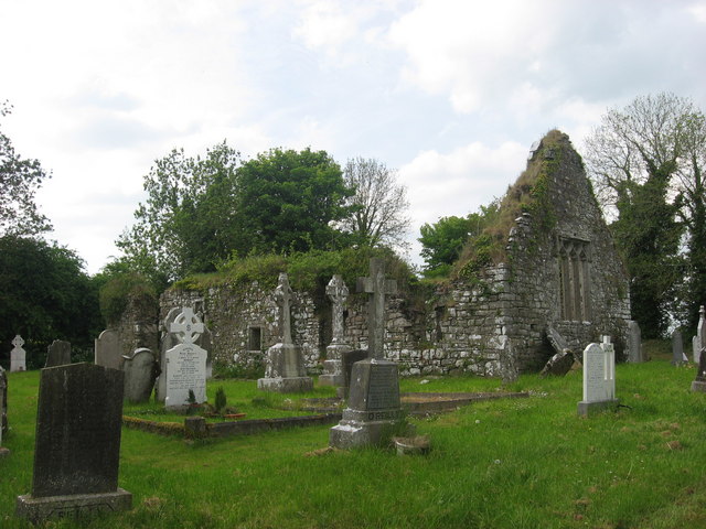
Situated on a level landscape. A church at Moyamet is listed in the ecclesiastical taxation (1302-06) of Pope Nicholas IV (Cal. doc. Ire. 5, 256). Ussher (1622) says the church and chapel were repaired (Erlington 1847-64, 1, lxxxiii) but Dopping (1682-5) says the church was ruined since 1641 and the graveyard was not enclosed (Ellison 1972, 10). The parish church of Moymet is within a rectangular graveyard (dims c. 50m N-S; c. 45m E-W) defined by earthen banks with trees, and it has headstones dating from c. 1772.
This is a divided nave (int. dims 12m plus E-W; 5.95m N-S) and chancel (int. dims 6.75m E-W; 5.05m N-S) structure that survives almost complete (H c. 3.5m) except that the W wall and adjacent parts of the long walls are missing (surviving L 20m). A pointed doorway (Wth 1.18m; H 1.81m) with an outer hollow chamfer is towards the W end of the N wall but the stoup is removed from its E jamb internally. A doorway in the S wall opposite is destroyed, but there is evidence of a window embrasure W of this doorway. The single-light cusped ogee-headed window (Wth 0.34m; H 1.13m) under a square hood moulding to the E of the S doorway is mirrored by a less complete one on the N wall. A stairs was added internally to the NE angle of the nave that provided access to the rood-loft, and corbels and beam-holes for the screen are present on the N and S nave walls. A rectangular window in the S wall lit the area behind the screen.
A rood screen was essential in this church as there was no chancel arch. There are two window embrasures in the S chancel wall and one in the N wall but little of the dressed stone survives. There is a rectangular aumbry (Wth 0.41m; H 0.38m; D 0.38m) with chamfered edges at the E end of the S wall and there is a statue-niche (Wth 0.45m; H 1.62m; D 0.38m) near it in the E wall. The E wall has a three-light cusped ogee-headed window with open spandrels and a square hood moulding, which can be dated to the early 15th century (O’Neill 2002, 18-30, fig. 44). The castle (ME030-023----) is c. 100m to the SE, the stone house (ME030-023001-) is c. 70m to the SE and the gatehouse (ME030-022----) is c. 90m to the ENE.
The above description is derived from the published 'Archaeological Inventory of County Meath' (Dublin: Stationery Office, 1987). In certain instances the entries have been revised and updated in the light of recent research.
Compiled by Michael Moore
Date of revision 8 January, 2014
The monument record does not grant public access. Check the route and ask the landowner before entering private land.