Add your own picture and explain the route, parking, gates, paths or landmarks that help people find it.
Earn 5 points after the picture is checked and accepted.
Add your photo and local directionsShare what you foundWhat is recorded here
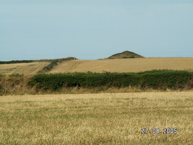
In pasture, immediately E of a road that forms townland boundary with Kyle and 100m S of townland boundary with Kilballyowen. A cist cemetery (LI040-009----) lies 200m to the NW. Not marked on OSi historic maps. Discovered in 1987 during the bulldozing of a mound (H c. 1m; diam. c. 10m) which was then excavated by Raghnall Ó Floinn of the National Museum of Ireland under Licence No. E1109, the results of which were summarised as follows; ‘The cist was uncovered in the course of levelling part of a mound, c. 1m in height and 10m in diameter. It was centrally placed and the mound had been erected over it. The short rectangular cist (0.85m by 0.6m) was overlain by two capstones, one on top of the other. The floor of the cist consisted of a single flagstone. It contained the cremated remains of two individuals accompanied by a piece of worked bone and by two food vessels – a tripartite bowl and a biconical vase – set mid-way along each of the long sides’ (Ó Floinn 1987, 19).
The excavation of this burial mound was recently described by Cahill & Sikora (2011, 255-62) as follows; 'In May 1987, a short cist containing cremated bone, two bowls and a bone object was discovered during the bulldozing of a mound at Baggotstown, near Bruff, Co. Limerick. The site was found near the centre of the mound when the capstones of the cist were struck by the machine. Both vessels had been removed from the cist by Mr J. Crowe, who then reported the find to the NMI. A rescue excavation was undertaken by Raghnall Ó Floinn. The human remains from the site were analysed by Barra Ó Donnabháin.
The mound was located along the west side of a field, and the field fence curves slightly around the western edge of the mound. The cist was in the centre of the mound, which measured c. 1m high by 10m in diameter and had clearly been dug into the old ground level. Approximately half of the mound (the southern half) had been removed in the bulldozing. Hollow spaces between the boulders above and to the west of the cist and a protruding flagstone at least 0.7m long by 0.1m thick suggested the possibility of a second cist set in the body of the mound, but the area was not investigated at this time.
The cist was rectangular in plan, with its long axis aligned approximately north/south. It measured 0.85m long by 0.6m wide by 0.4m deep internally at floor level. It had originally been formed of four main edge-set slabs, but the eastern side stone had been badly shattered by the disturbance and the southern end stone had split, perhaps in antiquity, owing to the pressure of the capstone. The slabs would originally have been substantial in size, the western side stone measuring 1.01m long by 0.18m thick by approximately 0.4m high. The end slabs had been set between the ends of the long sides and these now inclined inwards. A number of small stones had been wedged in the spaces between the end and side stones and also between the capstone and the side stones. All of the cist slabs were limestone of local provenance. The floor of the cist was formed of a rectangular flagstone measuring 0.78m by 0.55m, which fitted against the sides except along the west, where there was a gap of 0.02–0.03m. The cist was covered by two capstones, one on top of the other. Only one of these remained on site at the time of excavation; this was roughly triangular in outline and measured 1.15m long by 1.06m wide.
The cist contained the cremated remains of an adult male and a juvenile (1987:50), two bowls and a polished bone cylinder. Two fragments of animal bone and an animal tooth, probably that of a cow, were found among the cremation. Soil and sods had clearly slipped into it on discovery. On removal, it appeared that a deposit of cremated bone had been spread out on the floor of the cist. At its centre it measured 0.12m thick but was spread into the floor of the cist close to the northern side stone, and mixed through the fill along the eastern side of the cist were small mollusc shells. A sample of the cremation from the cist yielded a date of 3495±40 BP, which calibrates to 1923–1695 BC. Brindley (2007, 248) places both vessels in stage 3 of the bowl typology, which is dated to 1980–1930/20 BC.'.
Monument visible today as a scrub covered circular-shaped mound on Digital Google orthoimage taken between 2011-13 and on Google Earth orthoimages.
See attached plan of monument taken from Cahill and Sikora and Google Earth orthoimages
Compiled by: Fiona Rooney
Date of upload: 20 May 2021
The monument record does not grant public access. Check the route and ask the landowner before entering private land.