Add your own picture and explain the route, parking, gates, paths or landmarks that help people find it.
Earn 5 points after the picture is checked and accepted.
Add your photo and local directionsShare what you foundWhat is recorded here
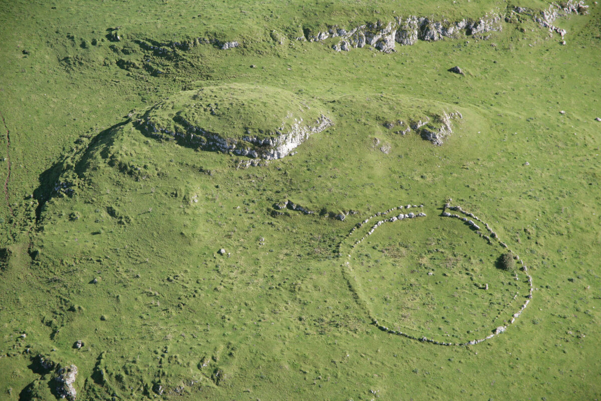
National monument No. 247. Carraig Aille cashel situated in area of rock outcrop 200m E of a small lake that was drained in the 19th century and which formed part of Lough Gur. The small lake had two islands known as 'Balie Islands' which are the remains of two crannóga (LI032-039001-/002-). A settlement cluster (LI032-053041-) and a second cashel (LI032-053003-) lie 40m to SE, three excavated stone structures (LI032-052----) were excavated by Ó Ríordáin in field to NNW. Carraig Aille stone fort was excavated by Ó Ríordáin (1949, 39) which he listed as Carraig Aille I, the cashel 40m to SE he listed as Carraig Aille II. Prior to excavation the cashel was described as following; 'The fort which we have called Carraig Aille I was, before excavation, much more clearly defined than was Carraig Aille II [LI032-053003-], though excavation showed it to be less impressive structurally than the latter. The outline, of Carraig Aille I is oval, enclosing the highest part of the hill. The fort wall was approximately of the same thickness as Carraig Aille II - between 11' [3.35m] and 14' [4.3m] - but the area enclosed was less. The greatest overall diameter in this case was about 140' [42.6m]. Much of the outer face of the rampart was to be seen before excavation, standing to an average height of about 3' [0.9m]. The stones tended to be larger but not as well selected nor as well placed as those in Carraig Aille II. Steps giving access to the top of the rampart, again similar to those in Carraig Aille II, were found, but only in two places, north of the entrance and almost directly opposite it; the steps were 8" [2.4m] and 3' [0.9m] wide. A more doubtful step was provided in the rampart to the south-west by the setting back of a single stone. On the northern side of the fort part of the rampart had been removed in the course of stone quarrying which had cut deeply into the hill here. Before excavation no trace of building could be seen within the fort, but the position of the entrance was evident. Over the interior of the fort, particularly towards the centre, rock knolls outcropped and gave evidence of the feature of the site which was particularly noted during the excavation the uneven rocky surface which had been enclosed by the fort builders.
The entrance was to the east and had, as in Carraig Aille II, a recess at either side. These recesses, however, were less neatly built than those in the other fort. The southern recess was 8" [0.2m] deep and 5' 2" [1.6m] in length, the northern recess was about 6' [1.8m] deep and 5' 8" [1.7m] in length. The width between them averaged 7' 9" [2.4m]. The dimensions show that neither recess could be used to contain the gate if this were made in one piece. The rock surface in the entrance was found to be covered by black habitation material, but over this flat stones representing fragments of a paving were found. Within the fort portions of paving occurred. These were found mainly inside the rampart on the south and south-east and there was a small area of paving near the steps north of the entrance. Associated with the paving on the southern sides were traces of walls of houses. These belonged to rectangular houses with rooms of varying sizes. About 7' [2.1m] inside the south-western corner of the entrance was a small compartment less than 4' [1.2m] square internally which can hardly have served for any other purpose than as a shelter for a single person - perhaps for a sentry' (Ó Ríordáin 1949, 52-4).
Ó Ríordáin (1949, 109) concluded that 'in the case of Carraig Aille I the iron hand-pinmay, it has been suggested, date to the seventh century and for the beads with "rope" ornament evidence has been given that they occurred in a tenth century context. The remainder of the material is similar to that from Carraig Aille II [LI032-053003-] though the number of outstanding finds is small -the meagre quantity of bronze being especially marked. The dating of the two sites would, therefore, appear to be parallel and the economy similar, that of Carraig Aille I being on a poorer level. Again, steps were constructed in the rampart at the south side of Carraig Aille II but were absent on the north side although the level ground here would have made attack feasible This may have been due to the fact that the contemporary occupation of Carraig Aille I provided sufficient protection on the north. From consideration of the sites themselves it is reasonable to argue that Carraig Aille I, being placed on the highest point of the hill, was probably built before Carraig Aille II, since defence considerations must have been of importance in siting. The houses north of Carraig Aille II were, we have argued, inhabited during the latter part of the occupation of this fort but were in part built before the rampart had seriously collapsed. They represent a stage at which an open undefended settlement was appropriate to the conditions of the times, as does also the house south of the fort. The building of houses on the rampart on the west emphasises this abandoning of a defensive mentality'.
Compiled by: Caimin O'Brien
Date of upload: 24 May 2018
See attached ASI aerial photograph ASIAP – 349/5 taken 05/01/2003.
The monument record does not grant public access. Check the route and ask the landowner before entering private land.