Add your own picture and explain the route, parking, gates, paths or landmarks that help people find it.
Earn 5 points after the picture is checked and accepted.
Add your photo and local directionsShare what you foundWhat is recorded here
Castle Connell stands on the summit of an isolated rock close by the town, and within a short distance of the river Shannon, in 1199 King John granted five knight's fees to William de Burgh, including this parish, with a condition that he should erect a castle thereon (Lenihan 1866, 727). The castle was described by Westropp (1906-7, 83-5) as following; 'There was a residence (or fort) called Caslaun Uí Chonaing in 1174, where Dermot and Mahon O'Brien were blinded by their relative King Donald. In 1200 Cathal Crovderg O'Conor and the Connaughtmen burned the bawn (Ann.F.M.). The next year W. de Burgo was granted Castle Canick. "If he fortify the castle," adds King John, "and we desire to have it, we will give him an exchange" (Ware). 1242 R. de Burgo held the manor of Castro Conign, worth £57 10s. 11½d. (C.S.P.I.). 1245 Phil de Inteberg, Constable of Limerick, is ordered to deliver up Castle Coning (C.S.P.I.). 1261 It was destroyed by the Irish under King Conor na Siudaine O'Brien. 1272 and 1274 The manor of Castro Konyng, with C[astle]. Amory, Tristellaueran, &c, held by Walter de Burgo (Pipe R.). 1274 The King granted the C[astle]. to Theo le Butler. 1275 to T. de Clare. 1279 Butler was paid £100 for its loss (Close R.). 1285-7 de Burgo, the Earl of Ulster, and the men of Castroconyng harboured Terdeluath O'Brien (Prince of Thomond) before his raid on de Clare's lands at Cahirconlish and Grean (Plea R., and see Wars of Torlough). Walter de Burgo enlarged and strengthened it before 1299. In 1315 Castrum Congher wasted by the Bruces. (Wars of Torlough). 1317 Orders to Ric, Earl of Ulster, as to Castroconyn, &c. (R. Mem., m. 14). 1355 Ric. Bourke of Castro Conning licensed to treat with the Irish. From the Book of the Ui Mhaoilchonaires we learn its owners during the usually blank period of the later fourteenth and the fifteenth centuries. Walter Duff, son of Richard, made a partition of his lands (about 1400-1410); to his eldest son Richard, he gave Tiobraid Aronn (Tipperary), Caislean Ui Chonaing, and Cathair-Cinnleis; William, son of this Richard, held it circa 1450; his son Edm., circa 1490, and grandson William. The latter was knighted 1535, Pardon was granted to him in 1558; and, with his son Tybott, 1564 (Fiants Mary 274, Eliz, 902), he is described as W. Bourke mac Edm. of Kislaneyconnell, and created Baron Bourke of Castelconyll for his services against James of Desmond, 1580. Of his sons, Theobald fell in battle, 1578 three others were Barons in succession. In 1583 he held the "Castel et vill de Castleconell and fishing quarters" (Inq. Exch. Eliz. 9), called "Castel et vill de Ekonnell in Peroch. de Kestermoy" (Des. R., .37). The Lords of Castleconnell play a large part in the local history thenceforward. William fought in the civil war, sat in the Parliament of Kilkenny, and went over sea to Charles II. in the Netherlands, " trailing a pike in the Duke of York's Regiment." The C[astle]. surrendered to the Commonwealth, 1651; for it and the weir and courts see C.S. xxi., p. 4, & B. D., 107. In 1690 it was surrendered by Captain Barnwell to King William. On the retreat of the latter, the Irish occupied it till August 29th, 1691, when, after two days' siege, the garrison capitulated to the Prince of Hesse. Ginckell had the C[astle]. blown up soon afterward. William, the eighth Baron, fought for King James at Aughrim, and retired to France (Paper by James Grene Barry, R.S. A.I., vol. xix.,p. 192, and numerous other works). 1725 Transferred by W. Ford to Ralph Westrop of Carduggan, County Cork (Dub. Reg.).
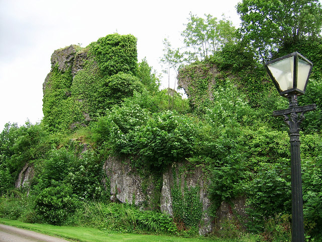
Fabric. - It stands on a steep flat-topped rock beside the Shannon. It is said to have had towers at each angle; traces remain to the south-west and north-west, with fragments of certain walls and well built arches. The court measures 160 feet [49m] by 100 feet [30m]. Local tradition attributes it to the O'Briens and its destruction to Cromwell [OSL Stradbally Parish]'.
The castle was described by Dowd (1896, 270) as measuring 'about one hundred and sixty feet [49m]
long by one hundred [30m] wide, and it probably had round towers at each of the four corners of the
rectangular area it enclosed. Of these only two can now be identified, and their resemblance to
the towers of King John's Castle at Limerick is striking'.
The castle was described by Salter (2004, 72) as standing on 'a 6m high vertical-sided rock near the Shannon are overgrown fragments of a 13th century de Burgh castle with a court measuring 48m by 30m with at least one circular tower. This building or its predecessor was destroyed in 1261 by Conor O'Brien'.
The destruction of the castle in 1691 was described by Ferrar (1787, 470) as following; 'The castle had a strong garrison of King James's forces, and General Ginkle sent 700 men from Limerick, under the command of the Prince of Hesse, when the garrison surrendered after a siege of two days. Ginkle considering it a strong hold, ordered it to be dismantled and blown up; the explosion was so great, that it shook the houses in Limerick and broke several windows. The castle was so spacious, and the ascent by steps so easy, notwithstanding its being built on a very high rock, that a troop of horse has been drawn up in the hall'.
Depicted as a large castellated structure overlooking the W bank of the River Shannon with medieval church (LI001-002001-) to S and a causeway or togher running through the bog to ENE on the 17th century Down Survey map of Stradbally parish (NLI, MS 718). This medieval roadway is annotated 'A Causyway' on the 17th century Down Survey map of Clanwilliam Barony (ibid.). The terrier of the Down Survey parish map recorded that in 1640 the castle of Castleconnell belonged to William Lord Bourk, Baron of Castleconnell (ibid.).
See 18th century engraving showing north view of castle taken from Ferrar's History of Limerick and Down Survey maps courtesy of the National Library of Ireland.
Compiled by: Caimin O'Brien
Date of upload: 7 February 2020
This remains an important historical record, but the official description says the monument is no longer visible or has been destroyed.
The monument record does not grant public access. Check the route and ask the landowner before entering private land.