Add your own picture and explain the route, parking, gates, paths or landmarks that help people find it.
Earn 5 points after the picture is checked and accepted.
Add your photo and local directionsShare what you foundWhat is recorded here
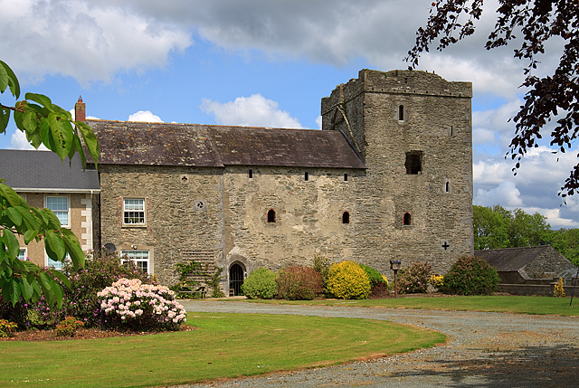
Built of roughly coursed limestone and greywacke rubble with limestone quoins, vertically set. It has a slight batter and is three storeys high over a N-S barrel vault. The castle is almost square in plan (c. 10m N-S, 8m E-W) with a stairwell in the SE angle and garderobes in the diagonally opposite one. The tower house was not accessible when visited in 1985 and the ground-floor level is being used as a farm building. More recent buildings used as part of the farmyard are attached to the W side of the tower house. They represent the remains of a house built when the tower house was abandoned. The now-occupied house is attached to the W end of the former dwelling.
There is a loop at ground level in the N facade constructed of hammer- and punch-dressed limestone with a single round-headed arch stone. There are two modern doorways in the E facade. That at the SE angle leads to the spiral stair which is now broken and not accessible. The other, which is in the centre of the wall, gives access to the barrel-vaulted area. There is no visible evidence of the original doorways. There is a cross-loop with expanded terminals in the N wall of the stairwell about three quarters of the way up from the ground level, and a large window at the W end of the S wall, now blocked, close to the top (i.e. third storey). The ope in the lower part of the N wall and the cross-loop in the stairwell indicate that this tower house is relatively late in the series. According to Tempest (CLAJ 1947, 186) the castle contained two large ornamental fireplaces. The one at the first-floor level was chamfered, punch-dressed and decorated with a pattern of ivy-like leaves. The other one was removed and re-set in the house adjoining at the W. It was decorated with a running pattern of leaves in relief and a quadruped with back-turned head. These cannot now be viewed because the present owner will not allow access owing to the dangerous condition of the building, but assurance was given that they were still in place. (CLAJ 1924, 267-8; CLAJ 1948, 314)
The above description is derived from both the published 'Archaeological Inventory of County Louth' (Dublin: Stationery Office, 1986) and the 'Archaeological Survey of County Louth' (Dublin: Stationery Office, 1991). In certain instances the entries have been revised and updated in the light of recent research.
Date of upload: 17 July 2007
The monument record does not grant public access. Check the route and ask the landowner before entering private land.