Add your own picture and explain the route, parking, gates, paths or landmarks that help people find it.
Earn 5 points after the picture is checked and accepted.
Add your photo and local directionsShare what you foundWhat is recorded here
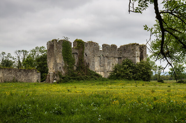
Adjoining the N wall of a tower house (LF017-009002-) and occupying and forming the NE corner of a bawn (LF017-009001-). In 1627 the English Crown granted Sir Thomas Dutton 'the castle [LF017-009002], town, and lands of Rathcline … with a clause creating those lands into a manor, to be called the Manor of Rathclyne (Cal. pat. rolls Ire., Chas I, 251). A house built by Dutton appears to have been remodelled c. 1667 by Sir George Lane who purchased the manor and lands of Rathcline in 1649 (Brown 1784, 227); an armorial plaque (LF017-009007-) commemorated this work.
A late 17th-century manuscript plan (NLI, MS 8646 (6)) indicates that the house was approximately H-shaped in plan, consisting of a central block aligned E-W, with asymmetrical E and W wings aligned N-S. The E wing was in line with the central block. It extended off the N wall of the tower house and projected beyond the line of the N wall of the bawn. A square-shaped angle tower of the bawn projected off its NE angle. The W wing projected to the S and N of the central block but did not extent as far N as the bawn wall. Another building, aligned E-W, extended off its W wall. The house was accessed through a classical doorway in the centre of the S wall of the central block and a stairway at its E end accessed the E wing. A wooden stairs is depicted against the external face of the N gable of this wing. Two buildings that were probably outhouses associated with the house are shown; one, aligned E-W, was built against the S wall of the bawn, to the W of the S gateway. The other, aligned N-S, was against the W wall, to the N of the W gateway. A formal walled garden (LF017-009008-), also with projecting angle towers, is depicted immediately to the E of the bawn and to its E a fish-pond (LF017-009005-). Another walled area, roughly trapezoidal in plan, is shown immediately to the S of the bawn and to its SE an orchard.
A household inventory dating to 1688 lists the various rooms, including ‘a Damask room, a dining-room, two drawing-rooms, My Lord’s dressing-room, parlour, parlour closet, Castle room and room adjoining, My Lady’s closet, Red room, room above Damask room, Madame Lane’s room and room adjoining, the Nurseries, the Lobby, butler’s garret, cook’s garret, and four other garrets’ (Cullen 1968, 56; NLI, MS 8646 (5)). Described in 1682 by Nicholas Dowdall as ‘a very noble and spacious house … being very pleasant and well Improved with Orchards, Gardens, Fishponds and a Deer Park [LF017-009004-]’ (Gillespie and Moran 1991, 208) but by 1793 it had been ‘dismantled by Cromwell, and finally burnt and reduced to its present ruinous state, in the wars of King James (Anon. 1793, 405). Late 18th-century illustrations by Henry Brocas and Daniel Grose (Stalley 1991, 76) depict the house as a ruinous three-storey shell of a building with tall chimney stacks rising high above the walls. The building extending off the W wing is also ruined and was possibly just one storey high.
Almost all of the walls of the house (int. dims. c. 12.9m N–S; 6.9m E–W) have been levelled but part of the E wing and the angle tower, which functioned as a service or bedroom tower of the house, and also served as the NE angle tower of the bawn, survive to a height of three storeys. The walls, which are rendered externally, are constructed of rubble limestone with alternating long and short quoins with drafted margins. String-courses, with concave moulding, on the N end of the W wall, the angle tower and the E wall of the E wing indicate the first- and second-floor levels. Two construction phases are evident - relating to the early and late 17th century – reflecting that the original house was subsequently remodelled and refurbished. The N end of the W wall (L 0.8m), the N gable (ext. L 7.86m; T 1.05m) and the E wall (ext. L 11m) of the E wing survive. The N gable projects 1.3m beyond the N wall of the bawn and the angle tower projects 0.8m to the E of the house. No windows are visible externally at ground-floor level but a blocked-up doorway (Wth 1.9m), located off-centre to the S, in the E wall cuts across the embrasure of a possible window and appears to have damaged the string course, which is partially missing, indicating that it was inserted when the house was remodelled in the late 17th century. This doorway accessed the formal gardens. The N splay of a destroyed window is visible on the first and second floors of the W wall. A twin-light window with a hood-moulding of early 17th century date is visible at the W end of the N gable on the first floor and one broken out window is evident above it on the second floor. The string courses are not visible on this wall as an external stairs, as depicted on the late 17th century plan (NLI, MS 8646 (6)), was built against it. A horizontal line of three beam holes indicates where it was keyed into the wall. It accessed a first-floor doorway in the W face of the angle tower. Two putlog holes are visible at first-floor level in the E wall, one of which has an original timber beam in situ. The windows in this wall reflect the two phases of construction: a fine cut-stone, early 17th century, transom and mullion window is centrally located on the first floor. Its hood-moulding projects slightly above the string course and forms part of it. The taller blocked-up vertical window openings to its N and S were inserted in the late 17th century. They may have accommodated wooden sash windows. The lower halves of two broken-out windows are visible on the second floor.
Internally a broken-out fireplace is visible off-centre to the W of the N gable at ground-floor level. There is a possible wall oven to its W and a wall cupboard to its E. At first-floor level are the remains of an impressive, cut-stone, square-headed, centrally located fireplace. Another broken-out fireplace with evidence of red brick infill is visible on the second floor. A row of joist holes (H 3.8m) indicate the first floor level. Broken-out doorways on the three floor levels in the NE angle of this wing accessed the angle tower.
All the walls of the angle tower (int. dims. 3.05m; 2.97m; wall T 0.9–1.15m) survive but there is a large central breach in its E wall. Slit opes in the W and S walls, at ground-floor level, probably functioned as a gun loops providing flanking fire along the N gable and E wall of the house. They date to the early 17th century and the example in the W wall was made redundant when the wooden stairs was built up against N gable of the E wing. The doorway that accessed the stairs is visible in the NW angle of the tower at first-floor level. No opes are evident in the N wall, which is rendered. The central breach in the E wall is on the line of broken-out windows. Partially destroyed and broken-out fireplaces are visible in the W wall at first- and second-floor levels. They appear to have been inserted when the house was refurbished, perhaps to facilitate bedroom accommodation. All the floors were wooden and were carried in the thickness of the wall. A deer park (LF017-009004-) is associated. (Loeber 1981, 51, 77, 113)
Compiled by: Caimin O'Brien
Date of upload: 5 July 2012
The monument record does not grant public access. Check the route and ask the landowner before entering private land.