Add your own picture and explain the route, parking, gates, paths or landmarks that help people find it.
Earn 5 points after the picture is checked and accepted.
Add your photo and local directionsShare what you foundWhat is recorded here
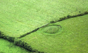
In pasture on a slight rise in gently undulating terrain with damp, rush-grown ground in the low-lying area. The N4 bypass lies within 15m, bordering the W side of the field. Shown on the 1837 ed. of the OS 6-inch map as a trapezoidal enclosure with angular corners. On later editions it is depicted with rounded corners giving it a roughly ovoid plan. It survives as an earthen platform (L NW side 35-40m; SW side c. 35-40m; NE side c. 30m), roughly ovoid in plan, narrowest at the NE end, defined by a bank, with remnants of an external fosse evident at SW. The NW and SE sides appear somewhat linear but have rounded corners. The bank (Wth 3.5m; int. H 0.3m at N, 0.2-0.3m at SW; ext. H 1.6m at N, 1.6m at SW) is low and degraded internally but has a pronounced external face which is cut almost to the vertical. From N–NE a section (L 10-12m) of the bank is incorporated into the line of a property boundary. The fosse (Wth base 2.5m; ext. D 0.65m) can be traced at SW for 12-15m as a well-defined depression but then peters out. At N a slight dip, bordered externally by the field fence, may also be evidence of it. The interior is level but can only be examined in parts in the NE half; the SW half is covered by impenetrable blackthorn and brambles. A break (Wth 1.4m) in the bank at E is marked on the external edge of its S terminal by a boulder. Elsewhere there are numerous narrow breaks or slumped areas (max. Wth c. 1m) eroded by farm stock. The enclosure is engulfed in a thicket of overgrowth making inspection difficult.
Compiled by: Jane O’Shaughnessy
Date of upload: 9 January 2013
The monument record does not grant public access. Check the route and ask the landowner before entering private land.