Add your own picture and explain the route, parking, gates, paths or landmarks that help people find it.
Earn 5 points after the picture is checked and accepted.
Add your photo and local directionsShare what you foundWhat is recorded here
An Early Christian monastery was founded here in the sixth century by st Cainnech (Canice). It was plundered and burnt a number of times, and in 1234 was rebuilt as an Augustinian priory (Harbison 1970, 139). A Dominican friary, founded by Florence MacGillapatrick, Lord of Ossory, was built close by in 1382. It was suppressed in 1540 (Gwynn and Hadcock 1970, 221).
The present Protestant church stands on the site of the Augustinian church (LA022-019002-). Some of its windows are from the nearby Dominican church (Harbison ibid.). The belfry tower, with its original plinth, dates to the thirteenth century, and has been refaced and added to in modern times. Its two-centred arched sandstone doorway probably dates to the fifteenth century. There is a medieval head on E side of doorway; two other similar heads are on the adjoining façade of the church. Medieval stonework is visible inside doorway to W. A horizontal grave slab (LA022-019005-), dated 1675, lies at E end of church and an octagonal font (LA022-019004-) lies outside entrance.
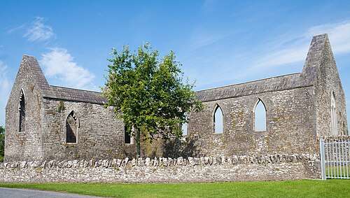
The Dominican church, to W, consists of a nave and chancel (L c. 32m, Wth c. 21m, Wall T c. 1.1m) with a transept at W end of S wall. Constructed mainly of rubble and limestone, its main features include a three-light window in E gable, a blocked-up doorway in W end of S wall, a similar doorway in N wall, which accessed the cloister, and a late medieval doorway in W wall. Within the church, set in e end of S wall, is an ogee-headed piscina with a six leafed scalloped bowl and central drain hole. The transept has a three-light tracery window in S wall, and remains of a piscina in E wall. Grass-covered remains of the cloister are visible to N of the church. Site of St Canice's Well (LA022-019006-) lies c. 180m to the SW.
St. Canice or Kenny founded an Abbey here before the year 577. In 1172 Aghaboe was granted to Adam de Hereford by Earl Strongbow. The town and church of Aghaboe were burned by Dermot MacGillapatrick in 1346. The Lord of Ossory, Florence, i.e. Finghin MacGillapatrick founded the Abbey here for the Dominicans in 1382. The first prior was John O'Foelan. (Carrigan 1905, vol. 2, 26-47). In a low lying area. A late Medieval Abbey with undivided nave and chancel (L. c. 32m, W. c. 21m, T. c. 1.1m) with later transept added to West end of S wall around the year 1400, this transept was known as 'Phelans Chapel', constructed mainly of rubble limestone. The East gable consists of a three light window. In the West gable is a late Medieval doorway with ope above and in the West end of S wall is a blocked up doorway and a similar one in N wall which gave access to the cloister. There is a piscina with moulding, an ogee head and a scalloped 6 piece drain hole in E end of South wall. In the South wall of the transept are the remains of a three light window with tracery and in the East wall are the remains of a piscina and another in the E end of S wall. Grass covered remains of cloister are visible to N of nave and chancel of abbey.
Described in 1786 as 'The west and south windows were handsome Gothic work;the church was one hundred feet in length, and twenty-four in width. It had three windows to the south, one to the east, and one at the west. That to the east was ramified, the western doorway had concentric arches, and the walls of the abbey were not ornamented. In the centre, to the south was a small oratory or building, called Phelan's Chapel, and it was divided from the church by an arch, resting on a pillar of solida masonry. Between the east windows of this chapel was a pedestal, above the altar, intended for a statue. Under it was a stone, hollowed and shaped like an inverted cone, with eight grooves, supposed to be for holy water. To the present writer it appears to have been a piscina. A doot in the north side led into a quadrangle of sixty feet; the cells for the friars, usually ten in number, lay to the east and opposite thereto was the kitchen, with apartments for servants and necessary officers; the cellars were large, and over them was the prior's apartment, measuring forty-six feet by seventeen. At the end of this was a bed-chamber, seventeenth feet square. Whether or not this large room was the refectory could not be determined. The last vicar and predecessor of the Rev. Edward Ledwich in the parish demolished much of the building and made use of the materials to enclose a demesne. Originall there was a fireplace at the south end, and a stone staircase made a communication with the church and cellars. A very interesting copper-plate drawing of the old ruins at Aghaboe in 1792, when they were much more perfect than at present, may be found in Grose's "Antiquities of Ireland". This south-east aspect was drawn by Lieutenant Daniel Grose.' (O'Hanlon and O'Leary 1907, p. 173-4)
Restoration work at the fourteenth-century Dominican friary church at Aghaboe, Co. Laois, was undertaken by a local committee using an AnCO/ CYTP scheme. Virtually the entire N wall of the church was missing and as it was proposed to rebuild this wall an area 26.4m long x 3m wide was opened in an effort to trace the original foundations. The excavation, which lasted for five weeks, was funded by AnCO and undertaken by the Roscrea Archaeological Survey team. Five cuttings were opened, each 5m x 3m, and numbered 1-5 from the east. Cuttings 1 and 2 revealed decayed mortar in which, inside the line of the church wall, randomly scattered human bone lay at a depth of between 45cm and 90cm. In cuttings 3 and 4 the decayed mortar, varying in thickness between 5cm and 20cm, overlay a mixture of earth and decayed mortar with loose stone randomly mixed through it particularly over the line of the wall and outside it on the N. Beneath this was a layer of heavy yellow clay in which, inside the line of the wall, articulated and partly articulated skeletons lay at a depth of 55cm and below. These were laid coffinless with the feet pointing to the E, often closely placed on top of one another, sometimes with part of the lower skeleton removed to make place for the upper. In cutting S the same mixture of earth and mortar yielded only random human bone. At a depth of 80cm the deposit became blacker and more refined and contained two skeletons. In all, five intact and six incomplete skeletons were recovered. Two short sections of the foundations of the N wall of the church were exposed in cuttings 3 and 4. These measured 3.5m and 3m in length, 1.55m in width and survived to a height of 0.4m. The foundations rested on the heavy yellow clay which was probably brought to the site to provide a firm base on which to build the church. Very few artefacts were recovered, none in any clearly defined context. These included a worn coin or token, possibly of late 18th-century date; the bowl and three stem fragments of a clay pipe (all from different locations); a sherd of green/brown glazed pottery; the rim of a fairly large vessel and several smaller sherds of factory-made domestic ware; two lead weights, one with letters faintly incised on it, and several pieces of glass slag. The church wall foundations are medieval in date. The finds probably belong to the 18th/19th centuries and as they come from the same general context as the skeletons it is likely that the interments are of similar date. A full report of the excavation will appear in Éile 3 (1987).
Archaeological monitoring was carried out on the site in 1994 by Dominic Delany under excavation licence no. 94E050.
Archaeological test-excavation in advance of a proposed car park development was undertaken in April 1994. The site covers a large triangular-shaped area (Fair Green) measuring 90m north-south and narrowing from 32m at the north end to just 2m at the south end. The recently-restored 14th-century Dominican friary church stands to the north of the site and the existing parish church, incorporating the turret of a 13th-century Augustinian priory, stands to the north-east. On the 1st edition of the O
The monument record does not grant public access. Check the route and ask the landowner before entering private land.