Add your own picture and explain the route, parking, gates, paths or landmarks that help people find it.
Earn 5 points after the picture is checked and accepted.
Add your photo and local directionsShare what you foundWhat is recorded here
On the western foothills of the Castlecomer plateau on a N-S running ridge some 3km E of the village of Ballyragget, on the summit of Corrandhu Hill. The summit is a narrow elongated eminence, hollow in the centre, with a maximum height of just over 250m O.D. in the S where there is an O.S. trig. station. The land falls sharply to the E but westwards from the summit the slope is at first gradual as far as the 240m contour before again falling away steeply. The western slopes are now covered by a dense forestry plantation. N and S of the summit the slopes of the ridge are gradual but undulating.
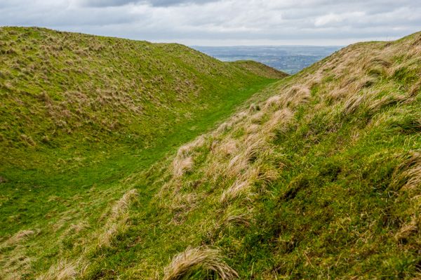
The hillfort consists of two widely spaced roughly concentric enclosures staddling the ridge and encircling the summit. The outer enclosure (diam. 330m N-S; 351m E-W) is sub-circular in plan. About 100m inside this is the second denuded oval enclosure (diam. 160m x 110m). The line of the outer rampart can be followed on the ground for most of its circuit. In the N, where the rampart cuts across the ridge, it survives as a scatter of small stones, thinly spread in an irregular bank (Wth 4-5m). These must be the last remnants of an original rubble core for no stones of any size were observed here. Gradually, as the line is traced eastwards, the concentration of stones becomes denser and acquires the appearance of a low mound (H c. 0.3m), the line of which is accentuated by growth of furze and fern. Around the E the bank curves down the steep slope as far as the 225m contour which it follows for about 150m before curing upwards again in the SE and across the ridge in the S. Around the E the line of the bank is emphasised by a field boundary of rubble constructed along its crest. A narrow gap in this sector is probably recent. In the SE the bank is scarcely traceable for about 100m but in the S, in a field of pasture, the rampart is plainly visible as a low rounded mound (Wth 4-5m; H 0.3-0.5m). In the SW, in two fields of pasture, the bank has been removed entirely. In the W the forestry plantation has obscured all details. The aerial photo [GSI 1:30,000, roll 47, print 13, 15], however, taken before the tree-planting, shows the rampart curving in an arc across the steeply-sloping ridge.
The inner rampart is not as easily recognisable as is the outer. It encircles the highest part of the summit following the contours of the hill only for a short distance in the E. In the N and NE, where the rampart crosses the ridge, it is recognisable as a scatter of stones similar to that of the outer rampart around this part of its circumference. Around the E the line of the enclosure can be followed as a broad mound (int. H 0.6m; ext. H 2.5m), densely covered in vegetation. It is not clear how much of the surviving rampart here is formed of a modern field boundary. On the ground the line of the inner rampart could not be traced in the W, but it shows as a faint shadow on the aerial photograph. (Barry Raftery, unpublished field report, 7 October 1986)
According to Carrigan (1905, vol. 2, 102) human bones (KK010-007002-) were found 'on the fringe of the plateau' during quarrying operations, as well as in the inner and outer ramparts. It is described in the Atlas of Hillforts of Britain and Ireland as having, 'a total footprint of 8.9ha. Bivallate for its entire circuit with three possible original entrances at NNW and SE identified through geophysics (O'Driscoll 2013). No evidence for any internal features on the surface, pits and a possible hut structure identified in geophysics. Enclosing elements survive as low-rise bank features. Targeted excavation by O'Brien (2013) and geophysical survey by O'Driscoll (2013). Late Bronze Age radiocarbon dates from ditch deposits and palisade features. Excavation (O'Brien 2013) and geophysical survey (O'Driscoll 2013) has revealed that the inner and outer enclosing elements consist of banks [largely of stone] with external ditches (the inner example being rock-cut) with small palisades abutting the inside of the banks. The inner ditch was approximately 1.4m deep and 2.5m wide. The outer ditch measured 1.2m in depth and 1.8m in width.' (http://hillforts.arch.ox.ac.uk/records/IR0677).
See attached photographs:
KK010-007001-_01 Archaeological Survey of Ireland aerial photograph (173) 13, 27 January 2001
KK010-007001-_02 Archaeological Survey of Ireland aerial photograph (173) 18, 27 January 2001
Compiled by: Jean Farrelly
Date of upload: 7 November 2018
This remains an important historical record, but the official description says the monument is no longer visible or has been destroyed.
The monument record does not grant public access. Check the route and ask the landowner before entering private land.