Add your own picture and explain the route, parking, gates, paths or landmarks that help people find it.
Earn 5 points after the picture is checked and accepted.
Add your photo and local directionsShare what you foundWhat is recorded here
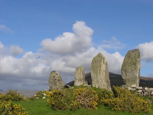
This site lies about 250m ESE of KE088-014---- and is bisected by a field boundary and drain. It is composed of ten orthostats arranged in an approximately rectangular plan, and is open at its SW end. It measures 7m NE-SW x 4.25m NW-SE. Five stones comprise the S side, the taller stones occurring at either end. They vary from .2m to 1.7m high and from .75m to 1.1m long. The second stone from W is partly incorporated into the field boundary, and a slab set at right angles to the side, which may have acted as a buttress, is exposed in the drain between the third and fourth stones. A large boulder is located immediately outside the westernmost stone, but does not appear to have formed part of the monument. Two stones survive at the monument's NE end. The S stone is .55m high and 1m long, while an overgrowth of sod largely conceals the stone at N. Two orthostats are all that remain of the NW side. The stone at W is 1.15m high and 1.25m long. Most of the second stone has been incorporated into the field boundary. Its exposed portion measures .68m high and .9m long. Henry interpreted the site to be remains of either a 'megalith or of a hut' (1957, 84).
The above description is derived from A. O'Sullivan and J. Sheehan (compilers), 'The Iveragh peninsula: an archaeological survey of South Kerry'. Cork University Press (1996), no. 1470. In certain instances the entries have been revised and updated in the light of recent research.
Date of upload: 1 August 2013
The monument record does not grant public access. Check the route and ask the landowner before entering private land.