Add your own picture and explain the route, parking, gates, paths or landmarks that help people find it.
Earn 5 points after the picture is checked and accepted.
Add your photo and local directionsShare what you foundWhat is recorded here
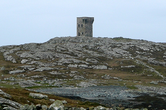
Situated towards the western edge of Golam Head, on Golam\Gólam, a small tidal islet off the western tip of Lettermullan Island\Leitir Mealláin (29m OD). The islet consists of low exposed limestone hills and short boggy valleys. Located on a small knoll with a shallow valley running away to the NE. The surrounding area consists of small irregularly-shaped fields defined by low drystone walls. The signal tower has unobstructed views in all directions. Site located c. 80m N of coastline at its closest point. The signal tower on Inishmore (GA110-133001-), located 12.5kms to the SSE, is clearly visible from here during good weather. The signal tower at Ard Castle Hill (GA076-006----), located c. 12.5kms to the NW, has been reduced to a low barely-defined ruins, and can no longer be seen from this location. This signal tower at Golam\Gólam is located c. 180m W of a holy well (GA089-014----), known locally as ‘Tobar Cholmcille’, and c. 2.63kms SW of the site of a Roman Catholic chapel (GA089-016----) on Lettermullan Island\Leitir Mealláin, now demolished.
An early nineteenth-century (c. 1804-6) two-storey square-plan signal tower, built with roughly coursed rubble stone masonry (int. dims. 4.25m NE-SW x 4.27m NW-SE; wall H 12.4m). This is one of the best surviving examples of its type on the W coast of Ireland, and survives to its full original height. The doorway is located to the centre of the SW elevation at first floor level, and would have been originally accessed via a retractable ladder. This doorway retains a cut limestone block-and start surround, cut limestone lintel to head with central keystone, and a cut limestone threshold to base. The doorway is protected by a rectangular machicolation over supported by three cut limestone corbelled supports that taper upwards and outwards to the base of the machicolation. The NW and SE elevations each feature two square-headed window openings at ground and first floor levels. The window openings at first floor level retain cut limestone block-and start surrounds, cut limestone lintels to heads with central keystones, and cut limestone sills. The ground floor window opening to the SW end of the SE elevation has been opened-up to form an entrance, and this new doorway has been framed with cement. The remaining windows openings at ground floor level have all been ‘repaired’ with similar cement rendered frames. Parts of the original timber framing of the windows remain in situ to a number of the window openings at first floor level. The NE wall bows out slightly to centre to create additional space in which to house the chimney flue. Square bartizans are located on the N and E corners, each supported by three cut limestone corbelled supports that taper upwards and outwards to the base of each bartizan. The majority of the parapet walls survive with much of the cut limestone coping also remaining insitu.
The internal space consisted of a semi-basement level which is partially infilled with soil, a ground floor room with a split mezzanine level, a first floor room, and a low attic level. The flat roof had been accessible from the attic level, and a parapet wall protected the edge of the roof and connected to the bartizans and the machicolation. The floors and the roof of the building had been wooden and were carried in the thickness of the wall. No parts of the floors or the roof have survived, but rows of joist holes indicate their former positions. The internal walls are covered in a layer of smooth lime render. The ground floor and first floor rooms feature centrally-positioned shallow segmental- (first floor) and square-headed (ground floor) fireplaces on the NE wall, flanked to either side by large shallow segmental-headed alcoves at first floor level and square-headed alcoves at ground floor level. The impressions of five shelves can be seen in the render that lines the alcoves at first floor level. A square-sectioned internal drainage channel runs down the N corner of the building. This is believed to have brought rainwater from the roof to storage barrels in the semi-basement.
The signal tower was not located in an enclosure. A crude drystone wall abuts the N corner of the signal tower, possibly a later addition. The wall runs off to the NW for a distance of approximately 100m.
The signal tower was part of a system of over 80 signal stations constructed by the British Board of Ordnance in the first decade of the 19th century to warn of the approach of a French invasion fleet. Signalling between sites was accomplished using a naval signal post. The system formed a continuous chain from Dublin Bay running clockwise all the way around the coast to Malin Head in County Donegal. It was abandoned by the mid-1810s when the threat of a French invasion diminished (Kerrigan 1995, 157-66).
Compiled by: Stuart Rathbone
Uploaded on: 12/07/22
Images:
GA089-013----.01 Oblique view from E
GA089-013----.02 Oblique view from N
GA089-013----.03 NW exterior
GA089-013----.04 NE exterior
GA089-013----.05 SW exterior
GA089-013----.06 SE exterior
GA089-013----.07 Oblique view from S
GA089-013----.08 Site overview from E
GA089-013----.09 Detail of window openings at first floor level to NW elevation
GA089-013----.10 NE interior
GA089-013----.11 NE interior 2; ground floor fireplace and alcoves
GA089-013----.12 NW interior
GA089-013----.13 NW interior; ground floor
GA089-013----.14 NW exterior drawing
GA089-013----.15 NE exterior drawing
GA089-013----.16 SW exterior drawing
GA089-013----.17 SE exterior drawing
GA089-013----.18 NW interior drawing
GA089-013----.19 NE interior drawing
GA089-013----.20 SW interior drawing
GA089-013----.21 SE interior drawing
GA089-013----.22 Plan of site
GA089-013----.23 SE interior
GA089-013----.24 SW interior
GA089-013----.25 SW interior; ground floor
The monument record does not grant public access. Check the route and ask the landowner before entering private land.