Add your own picture and explain the route, parking, gates, paths or landmarks that help people find it.
Earn 5 points after the picture is checked and accepted.
Add your photo and local directionsShare what you foundWhat is recorded here
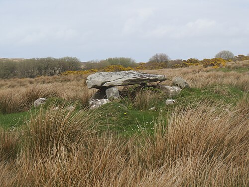
This monument is shown on the 1847-50 revision of the OS 6-inch map as a small rectangular enclosure but is not named. However, it is named 'Dermot and Grama's Bed' on the pre-publication field map. The monument, 6km NNW of the village of Ardara, is 1.6km N of Ballinreavy Strand, which is at the inner end of Loughros More Bay. It stands on rough, wettish, generally level pasture broken by outcropping rock and scattered erratics.
The monument consists of a small roofed chamber, 1.45m long and 1.2m wide, facing SSE. It stands close to the centre of a sub-oval grass-grown mound measuring 7.5m N-S by 11m E-W and 0.7m in overall height. Patches of peat on parts of the cairn suggest that the monument was at one stage substantially enveloped in bog.
A single stone forms each side of the chamber, and it is closed by a gabled backstone. Only the western portal-stone survives. This, the backstone and a small stone (not on plan) laid on top of the inner end of the eastern sidestone support the horizontally laid roof stone. Immediately in front of the western sidestone is a small firmly set stone (not hatched on plan) of uncertain status. It measures 0.3m by 0.15m and is 0.25m high. A stone, on edge, lying across the outer part of the chamber appears to be displaced. It measures 0.7m by 0.1m and rises 0.2m above the ground here. Several loose boulders (not on plan) lie around the site.
The portal-stone is 0.6m high. It rises 0.25m above the top of the western sidestone, which overlaps it. This sidestone is 0.35m high. The eastern sidestone is 0.6m high. The backstone, set beyond the chamber sides, is also 0.6m high. The small stone wedged between the underside of the roofstone and the top of the eastern sidestone is triangular and measures 0.15m by 0.08m by 0.05m thick. The roofstone, straight edged at the front, narrows to a point beyond the backstone. It is 2m long and up to 1.5m wide. Its inner half is 0.35m thick, and its outer half is 0.15-0.2m thick. A supposed 'shallow cup mark' on its upper surface (Crozier 1957) is probably of natural origin. Thomas Fagan (1845-8) visited the site in 1847, and it is clear from his account that the monument was then in the same condition as it is now.
This small megalithic chamber is classified as a portal tomb but with some reservation. The portal-stone is of exceptionally slight dimensions, and its complete overlap by the sidestone is an unusual feature.
Fagan 1845-8, book 22, 4; OS Revision Name Book, sheet 73 (1847-50), 34; Crozier 1957, 66-7 ('the Virgin's rock') and photograph no. 5 opposite p. 121; L. McGill 1964, 63 ('not marked on the OS 6-inch map'); Ó Nualláin 1968a, 297, no. 13; P.J. McGill 1970, 7 ('Lackaweer'); Ó Nualláin 1983a, 32, no. 56 (plan); Ó Nualláin 1983b, 94, Donegal no. 15; SMR 1987, 73:6; Ó Nualláin 1989, 124; RMP 1995, 73:6.
The above description was published in the 'Survey of the Megalithic Tombs of Ireland. Volume VI, County Donegal.' Compiled by: Eamon Cody (Dublin: Stationery Office, 2002).
Date of upload: 22 September 2008
See linked document with details from Eamon Cody, Survey of the Megalithic Tombs of Ireland. Volume VI. County Donegal. (Dublin: Stationery Office, 2002)
The monument record does not grant public access. Check the route and ask the landowner before entering private land.