Add your own picture and explain the route, parking, gates, paths or landmarks that help people find it.
Earn 5 points after the picture is checked and accepted.
Add your photo and local directionsShare what you foundWhat is recorded here
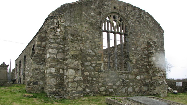
Tullyaughnish Old Church: Built by Sir William Stewart, the church was near completion in 1622 (Hill 1877, 525; Treadwell 1953-5, 42). It continued in use until a new parish church was built in 1822-6(Rowan 1979, 463).
The ivy-clad rubble-built church, 22.4m by 7.2m internally, has set-back corner buttresses and two others regularly spaced along the N wall. The upper section of the E gable has fallen and' the gable now presents a curvilinear outline. The four-light, round-headed E window with unusually thick mullions gives the anachronistic impression of a debased Perpendicular style. The visors are not dressed to accommodate the tracery and though the daggershaped centre-piece looks intrusive, it is tooled in a similar fashion to the rest of the window. Two moulded sections of tracery from some other window have been redressed and inserted in the tracery. The exterior is crowned with a hollow-bevelled hood-mould and above it a lintel from a splayed round-headed window incorporated in the wall. The ope has a pellet-moulded surround and the broad face is carved in false relief with a stylised tree between two lion-like creatures. It was brought from the old church on Aughnish island (Kinahan 1885-6, 424) and is probably 12th century in date (DG037-021). There are four large segment-headed windows in the S wall; the heads have been repaired and repointed with concrete. Some of the splayed ingoings are secondary and the masonry indicates that much of the upper section of the S wall is a later rebuilding, contemporary with these alterations. This is confirmed by an examination of the N wall where the surviving remains of the ingoings indicate that most of the three E windows were demolished and then blocked up when the wall was rebuilt. Seven mullion and three jamb fragments of similar date to those in the E window were reused as blocking material in the window at the E end of the N wall; some of these original 17th century windows must have had cut stone dressings with more than one light. At the W end of the N wall is a small blocked-up window with slightly pointed head and moulded jambs; part of the rear-arch and E ingoing is obscured by a 19th century memorial tablet. Some 2.5m E of the window, is a moulded fragment built into the exterior wall face. The W gable retains the lower courses of a bellcote which are partly preserved due to the secondary raising of the gable on either side by some 75-80cms. The gable had a large central oculus, 1.77 wide by 1.53m wide, now blocked-up. The moulded round-headed, sandstone, doorway is probably a secondary reconstruction; one of the S jamb stones is missing and the embrasure was reduced in width. The architectural evidence indicates that the church underwent major alterations and that these were probably carried out as part of a complete refurbishment of the building. It is possible that the tracery of the E window was removed at that time and subsequently rebuilt, its present haphazard arrangement being a local Gothick reconstruction.
The above description was derived from the 'Archaeological Survey of County Donegal. A description of the field antiquities of the County from the Mesolithic Period to the 17th century.' Compiled by: Brian Lacey with Eamon Cody, Claire Cotter, Judy Cuppage, Noel Dunne, Vincent Hurley, Celie O'Rahilly, Paul Walsh and Seán Ó Nualláin (Lifford: Donegal County Council, 1983). In certain instances the entries have been revised and updated.
Date of upload: 22 September 2008
The monument record does not grant public access. Check the route and ask the landowner before entering private land.