Add your own picture and explain the route, parking, gates, paths or landmarks that help people find it.
Earn 5 points after the picture is checked and accepted.
Add your photo and local directionsShare what you foundWhat is recorded here
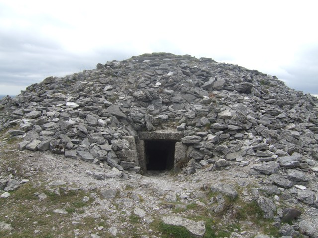
On summit of hill dominating N section of Clear Island. Chamber, open to NE, at centre of low cairn (diam. c. 15m). Five orthostats in line with N side of chamber, and a transversely set stone at exposed cairn edge may represent remains of passage. Stone, decorated with passage-tomb art (CO153-008---), found c. 1880 in townland of Croha West c. 1km to SW. (O'Leary 1989, 124-6) (Ó Nualláin 1989, 127).
The decorated stone (CO153-008----) and site of passage tomb (CO153-010----) from which the stone probably came from was described by O'Leary (1989, 124-6) as follows; 'In April 1984, however, an archaeological survey of Clear Island was undertaken, and on the top of the highest hill (533') in the townland of Killickaforavane, a sub-circular spread or cairn of stones was found c. 16m in diameter. In the middle of this cairn was a small hollow bounded on three sides by orthostats. The site consists of a sub-circular spread of boulders, slabs and stones measuring 16.5m NE by SW and 14m NW by SE. In the centre is a depression defined by five orthostats which line the SE, SW and NW sides. To the NE of this feature is a line of five orthostats running NE by SW. In line with these and at the edge of the stone.spread is an orthostat which is oriented NW by SE. There is a further single orthostat 1.5m south of the line of orthostats. Grasses and heather grow on and around the stone-spread on the little soil available and make it difficult to define the perimeter in places, especially in the west and south. There is some peat cover against south-west corner of the chamber: The orthostats vary, in height from 15cm above present ground level to 75cm above present ground level. In the north-west quadrant there is a dry-stone pillar/ approximately 2m in height and 2.75m in diameter. This appears have been formerly used as a trigonometrical station; a new one stands to the west of the site. Near the hilltop are stone field fences which, together with the dry-stone pillar, may have been constructed of stones from the site. As a result of research done by Mr Éamon Lankford of the Clear Island Museum Society, we now know that the decorated stone was found about 1880, in the townland of Croha West (not in the townland of Glen as previously thought) by a Mr Ó Síocháin and Mr Ó Ríogáin while engaged in clearing a field, then the property of a Mr Shipsey. Even without the evidence of the decorated stone, the site does suggest a megalithic monument of the Passage Tomb type. A sufficient number of orthostats remain in situ to trace a passage leading from the perimeter to the chamber in the centre of the cairn. The orientation of the passage falls well within the range of Irish passage tombs generally. The cairn diameter of c. 16m and the tomb length of 8m would place it in the small to medium examples of this type. The field in which the decorated stone was found is a half-mile to the south-west of the hilltop, at an elevation of under 300' [91m], and is beside the roadway to South Harbour. Mr Lankford's research revealed that fragments of pottery were found at the spot'.
See attached site plan taken from O'Leary 1989, 125.
The above description is derived from the published 'Archaeological Inventory of County Cork. Volume 1: West Cork' (Dublin: Stationery Office, 1992). In certain instances the entries have been revised and updated in the light of recent research.
Revised by: Caimin O'Brien
Date of revised upload: 25 August 2022
The monument record does not grant public access. Check the route and ask the landowner before entering private land.